Pavlovo geodata
Pavlovo (Nizhny Novgorod Oblast) is a populated place; located in Russia in Europe/Moscow (GMT+3) time zone. With population of 63,338 people, there are 323 cities with bigger population in this country. Compared to other cities in Russia, 66.2% of cities are located further ↓South; 56.3% of cities are located further →East and 58.2% of cities have higher elevation than Pavlovo. Note1


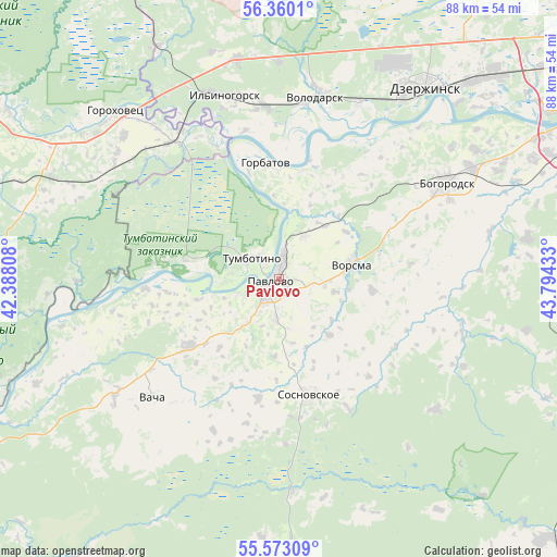
Pavlovo GPS coordinates[2]
55° 58' 6.96" North, 43° 5' 28.32" East
| Map corner | latitude | longitude |
|---|---|---|
| Upper-left | 56.3601°, | 42.38808° |
| Center: | 55.9686°, | 43.0912° |
| Lower-right: | 55.57309°, | 43.79433° |
| Map W x H: | 87.5×87.5 km | = 54.4×54.4mi |
| max Lat: | 73.50819° ⇑33.8% North |
| Pavlovo: | 55.9686° |
| min Lat: | ⇓66.2% South 41.28413° |
| min Long | Pavlovo | max Long |
| -179.12198° | 43.0912° | 179.35046° |
| W 43.7%⇐ | ⇒56.3% E |
Elevation
Elevation of Pavlovo is 128 m = 420 ft, and this is 74.6 m = 245 ft below average elevation for this country.
| Max E: |
2518 m = 8261 ft | 58.2% |
| Avg. | 202.6 m = 665 ft | |
| Pavlovo | 128 m = 420 ft | |
Min E: |
-28 m = -92 ft | 41.8% |
See also: Pavlovo elevation on elevation.city.
Geographical zone
Pavlovo is located in North temperate zone (between Tropic of Cancer and the Arctic Circle). Distance of this North polar circle is 1178 km =732 mi to North.| Distance of | km | miles | from Pavlovo |
|---|---|---|---|
| North Pole | 3783.9 | 2351.2 | to North |
| Arctic Circle | 1178 | 732 | to North |
| Tropic Cancer | 3617.2 | 2247.6 | to South |
| Equator | 6223.1 | 3866.9 | to South |


Nearby cities:
15 places around Pavlovo: (largest is in red/bold)
• Bogorodsk
30.3 km =18.8 mi,  59°
59°
• Galitsy
27.8 km =17.3 mi,  326°
326°
• Gorbatov
18.1 km =11.2 mi,  354°
354°
• Ilyinogorsk
30 km =18.6 mi,  343°
343°
• Novosmolinskiy
35.2 km =21.9 mi,  355°
355°
• Reshetikha
30.1 km =18.7 mi,  23°
23°
• Smolino
34.1 km =21.2 mi, 359°
• Sosnovskoye
18.8 km =11.7 mi,  165°
165°
• Taremskoye
5.3 km =3.3 mi,  213°
213°
• Tumbotino
5.4 km =3.4 mi,  309°
309°
• Vacha
27.1 km =16.8 mi,  227°
227°
• Volodarsk
29.8 km =18.5 mi,  11°
11°
• Vorsma
11.5 km =7.1 mi,  77°
77°
• Yuganets
32.5 km =20.2 mi, 15°
• Zhelnino
31 km =19.3 mi,  33°
33°
Sources, notices
• [Note1] Compared only with cities in Russia existing in our database
• [Src1] Map data: © OpenStreetMap contributors (CC-BY-SA)
• [Src2] Other city data from geonames.org with taken over terms of usage.
• [Src3] Geographical zone / Annual Mean Temperature by Robert A. Rohde @ Wikipedia
