Dedenëvo geodata
Dedenëvo (Moscow Oblast) is a populated place; located in Russia in Europe/Moscow (GMT+3) time zone. With population of 6,455 people, there are 2138 cities with bigger population in this country. Compared to other cities in Russia, 69.8% of cities are located further ↓South; 81.6% of cities are located further →East and 59.9% of cities have lower elevation than Dedenëvo. Note1


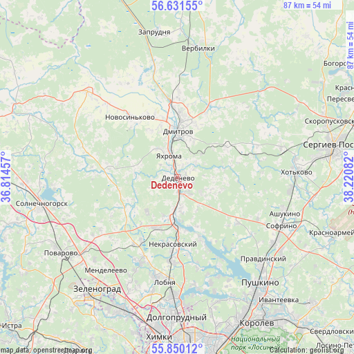
Dedenëvo GPS coordinates[2]
56° 14' 34.188" North, 37° 31' 3.684" East
| Map corner | latitude | longitude |
|---|---|---|
| Upper-left | 56.63155°, | 36.81457° |
| Center: | 56.24283°, | 37.51769° |
| Lower-right: | 55.85012°, | 38.22082° |
| Map W x H: | 86.9×86.9 km | = 54×54mi |
| max Lat: | 73.50819° ⇑30.2% North |
| Dedenëvo: | 56.24283° |
| min Lat: | ⇓69.8% South 41.28413° |
| min Long | Dedenëvo | max Long |
| -179.12198° | 37.51769° | 179.35046° |
| W 18.4%⇐ | ⇒81.6% E |
Elevation
Elevation of Dedenëvo is 168 m = 551 ft, and this is 34.6 m = 114 ft below average elevation for this country.
| Max E: |
2518 m = 8261 ft | 40.1% |
| Avg. | 202.6 m = 665 ft | |
| Dedenëvo | 168 m = 551 ft | |
Min E: |
-28 m = -92 ft | 59.9% |
See also: Russia elevation on elevation.city.
Geographical zone
Dedenëvo is located in North temperate zone (between Tropic of Cancer and the Arctic Circle). Distance of this North polar circle is 1147.6 km =713.1 mi to North.| Distance of | km | miles | from Dedenëvo |
|---|---|---|---|
| North Pole | 3753.4 | 2332.3 | to North |
| Arctic Circle | 1147.6 | 713.1 | to North |
| Tropic Cancer | 3647.7 | 2266.6 | to South |
| Equator | 6253.6 | 3885.8 | to South |


Nearby cities:
15 places around Dedenëvo: (largest is in red/bold)
• Avtopoligon
16.9 km =10.5 mi,  314°
314°
• Budenovetc
16.7 km =10.4 mi,  24°
24°
• Dmitrov
11.3 km =7 mi,  0°
0°
• Gorshkovo
16.1 km =10 mi,  336°
336°
• Ignatovo
8.1 km =5 mi,  170°
170°
• Iksha
8 km =5 mi,  188°
188°
• Kamenka
15 km =9.3 mi,  243°
243°
• Marfino
19.1 km =11.9 mi, 172°
• Nekrasovskiy
16.6 km =10.3 mi,  183°
183°
• Novosin’kovo
19 km =11.8 mi,  322°
322°
• Pod"yachevo
16.7 km =10.4 mi,  277°
277°
• Podosinki
4.2 km =2.6 mi,  154°
154°
• Rybnoye
20 km =12.4 mi, 18°
• Yakhroma
6.7 km =4.2 mi, 341°
• Yermolino
10.6 km =6.6 mi, 188°
Sources, notices
• [Note1] Compared only with cities in Russia existing in our database
• [Src1] Map data: © OpenStreetMap contributors (CC-BY-SA)
• [Src2] Other city data from geonames.org with taken over terms of usage.
• [Src3] Geographical zone / Annual Mean Temperature by Robert A. Rohde @ Wikipedia
