Ignatovo geodata
Ignatovo (Moscow Oblast) is a populated place; located in Russia in Europe/Moscow (GMT+3) time zone. With population of 680 people, there are 4832 cities with bigger population in this country. Compared to other cities in Russia, 68.9% of cities are located further ↓South; 81.4% of cities are located further →East and 65.4% of cities have lower elevation than Ignatovo. Note1


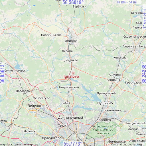
Ignatovo GPS coordinates[2]
56° 10' 14.664" North, 37° 32' 21.3" East
| Map corner | latitude | longitude |
|---|---|---|
| Upper-left | 56.56019°, | 36.83613° |
| Center: | 56.17074°, | 37.53925° |
| Lower-right: | 55.7773°, | 38.24238° |
| Map W x H: | 87×87 km | = 54.1×54.1mi |
| max Lat: | 73.50819° ⇑31.1% North |
| Ignatovo: | 56.17074° |
| min Lat: | ⇓68.9% South 41.28413° |
| min Long | Ignatovo | max Long |
| -179.12198° | 37.53925° | 179.35046° |
| W 18.6%⇐ | ⇒81.4% E |
Elevation
Elevation of Ignatovo is 183 m = 600 ft, and this is 19.6 m = 64 ft below average elevation for this country.
| Max E: |
2518 m = 8261 ft | 34.6% |
| Avg. | 202.6 m = 665 ft | |
| Ignatovo | 183 m = 600 ft | |
Min E: |
-28 m = -92 ft | 65.4% |
See also: Russia elevation on elevation.city.
Geographical zone
Ignatovo is located in North temperate zone (between Tropic of Cancer and the Arctic Circle). Distance of this North polar circle is 1155.6 km =718.1 mi to North.| Distance of | km | miles | from Ignatovo |
|---|---|---|---|
| North Pole | 3761.5 | 2337.3 | to North |
| Arctic Circle | 1155.6 | 718.1 | to North |
| Tropic Cancer | 3639.7 | 2261.6 | to South |
| Equator | 6245.6 | 3880.8 | to South |


Nearby cities:
15 places around Ignatovo: (largest is in red/bold)
• Dedenëvo
8.1 km =5 mi,  350°
350°
• Dmitrov
19.4 km =12.1 mi,  356°
356°
• Iksha
2.5 km =1.6 mi,  273°
273°
• Kamenka
14.9 km =9.3 mi,  275°
275°
• Lobnya
18.3 km =11.4 mi,  191°
191°
• Lugovaya
13.9 km =8.6 mi, 194°
• Marfino
11 km =6.8 mi,  173°
173°
• Nekrasovskiy
8.9 km =5.5 mi,  196°
196°
• Pod"yachevo
20.7 km =12.9 mi,  299°
299°
• Podosinki
4.2 km =2.6 mi,  6°
6°
• Poselok Turisticheskogo pansionata "Klyazminskoe vodohranilische"
21.2 km =13.2 mi,  157°
157°
• Yakhroma
14.8 km =9.2 mi, 346°
• Yel’digino
18.2 km =11.3 mi,  109°
109°
• Yermolino
3.8 km =2.4 mi,  230°
230°
• Zhostovo
18.5 km =11.5 mi, 158°
Sources, notices
• [Note1] Compared only with cities in Russia existing in our database
• [Src1] Map data: © OpenStreetMap contributors (CC-BY-SA)
• [Src2] Other city data from geonames.org with taken over terms of usage.
• [Src3] Geographical zone / Annual Mean Temperature by Robert A. Rohde @ Wikipedia
