Kamenka geodata
Kamenka (Moscow Oblast) is a populated place; located in Russia in Europe/Moscow (GMT+3) time zone. With population of 718 people, there are 4797 cities with bigger population in this country. Compared to other cities in Russia, 69.1% of cities are located further ↓South; 83.4% of cities are located further →East and 72.3% of cities have lower elevation than Kamenka. Note1


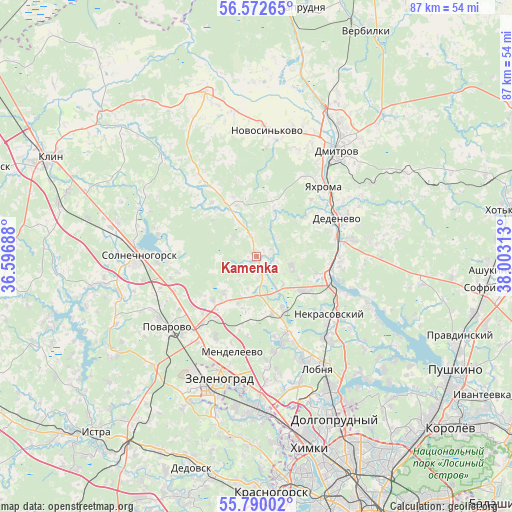
Kamenka GPS coordinates[2]
56° 10' 59.988" North, 37° 18' 0" East
| Map corner | latitude | longitude |
|---|---|---|
| Upper-left | 56.57265°, | 36.59688° |
| Center: | 56.18333°, | 37.3° |
| Lower-right: | 55.79002°, | 38.00313° |
| Map W x H: | 87×87 km | = 54.1×54.1mi |
| max Lat: | 73.50819° ⇑30.9% North |
| Kamenka: | 56.18333° |
| min Lat: | ⇓69.1% South 41.28413° |
| min Long | Kamenka | max Long |
| -179.12198° | 37.3° | 179.35046° |
| W 16.6%⇐ | ⇒83.4% E |
Elevation
Elevation of Kamenka is 206 m = 676 ft, and this is 3.4 m = 11 ft above average elevation for this country.
| Max E: |
2518 m = 8261 ft | 27.7% |
| Kamenka | 206 m 676 ft | |
| Avg. | 202.6 m = 665 ft | |
Min E: |
-28 m = -92 ft | 72.3% |
See also: Russia elevation on elevation.city.
Geographical zone
Kamenka is located in North temperate zone (between Tropic of Cancer and the Arctic Circle). Distance of this North polar circle is 1154.2 km =717.2 mi to North.| Distance of | km | miles | from Kamenka |
|---|---|---|---|
| North Pole | 3760.1 | 2336.4 | to North |
| Arctic Circle | 1154.2 | 717.2 | to North |
| Tropic Cancer | 3641.1 | 2262.5 | to South |
| Equator | 6247 | 3881.7 | to South |


Nearby cities:
15 places around Kamenka: (largest is in red/bold)
• Avtopoligon
18.6 km =11.6 mi,  4°
4°
• Chashnikovo
18.6 km =11.6 mi,  206°
206°
• Dedenëvo
15 km =9.3 mi,  63°
63°
• Ignatovo
14.9 km =9.3 mi,  95°
95°
• Iksha
12.3 km =7.6 mi, 95°
• Lozhki
15.5 km =9.6 mi,  229°
229°
• Lugovaya
18.7 km =11.6 mi,  142°
142°
• Mendeleyevo
17.5 km =10.9 mi,  197°
197°
• Nekrasovskiy
15.9 km =9.9 mi,  128°
128°
• Peshki
15.5 km =9.6 mi,  248°
248°
• Pod"yachevo
9.4 km =5.8 mi,  340°
340°
• Podosinki
15.6 km =9.7 mi,  79°
79°
• Radumlya
15.8 km =9.8 mi,  216°
216°
• Yakhroma
17.2 km =10.7 mi,  41°
41°
• Yermolino
12.4 km =7.7 mi,  107°
107°
Sources, notices
• [Note1] Compared only with cities in Russia existing in our database
• [Src1] Map data: © OpenStreetMap contributors (CC-BY-SA)
• [Src2] Other city data from geonames.org with taken over terms of usage.
• [Src3] Geographical zone / Annual Mean Temperature by Robert A. Rohde @ Wikipedia
