Brateyevo geodata
Brateyevo (Moscow) is a section of populated place; located in Russia in Europe/Moscow (GMT+3) time zone. With population of 102,000 people, there are 203 cities with bigger population in this country. Compared to other cities in Russia, 60.5% of cities are located further ↓South; 79.2% of cities are located further →East and 62.5% of cities have higher elevation than Brateyevo. Note1


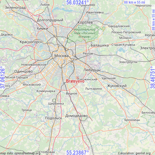
Brateyevo GPS coordinates[2]
55° 38' 15.18" North, 37° 45' 51.768" East
| Map corner | latitude | longitude |
|---|---|---|
| Upper-left | 56.03241°, | 37.06126° |
| Center: | 55.63755°, | 37.76438° |
| Lower-right: | 55.23867°, | 38.46751° |
| Map W x H: | 88.3×88.3 km | = 54.9×54.9mi |
| max Lat: | 73.50819° ⇑39.5% North |
| Brateyevo: | 55.63755° |
| min Lat: | ⇓60.5% South 41.28413° |
| min Long | Brateyevo | max Long |
| -179.12198° | 37.76438° | 179.35046° |
| W 20.8%⇐ | ⇒79.2% E |
Elevation
Elevation of Brateyevo is 119 m = 390 ft, and this is 83.6 m = 274 ft below average elevation for this country.
| Max E: |
2518 m = 8261 ft | 62.5% |
| Avg. | 202.6 m = 665 ft | |
| Brateyevo | 119 m = 390 ft | |
Min E: |
-28 m = -92 ft | 37.5% |
See also: Brateyevo elevation on elevation.city.
Geographical zone
Brateyevo is located in North temperate zone (between Tropic of Cancer and the Arctic Circle). Distance of this North polar circle is 1214.9 km =754.9 mi to North.| Distance of | km | miles | from Brateyevo |
|---|---|---|---|
| North Pole | 3820.7 | 2374.1 | to North |
| Arctic Circle | 1214.9 | 754.9 | to North |
| Tropic Cancer | 3580.4 | 2224.8 | to South |
| Equator | 6186.3 | 3844 | to South |


Nearby cities:
15 places around Brateyevo: (largest is in red/bold)
• Alekseyevka
2.4 km =1.5 mi,  110°
110°
• Dzerzhinskiy
5.9 km =3.7 mi,  98°
98°
• Dzerzhinsky
6 km =3.7 mi, 100°
• Kapotnya
1.8 km =1.1 mi,  88°
88°
• Kolomenskoye
6 km =3.7 mi,  302°
302°
• Kotel’niki
5 km =3.1 mi, 92°
• Kur’yanovo
4.3 km =2.7 mi,  288°
288°
• Lyublino
4.4 km =2.7 mi,  356°
356°
• Mar’ino
3.3 km =2.1 mi, 294°
• Novyye Kuz’minki
7 km =4.3 mi,  352°
352°
• Orekhovo-Borisovo
3.7 km =2.3 mi,  220°
220°
• Orekhovo-Borisovo Severnoye
5.6 km =3.5 mi,  245°
245°
• Orekhovo-Borisovo Yuzhnoye
2 km =1.2 mi,  256°
256°
• Razvilka
5.3 km =3.3 mi,  196°
196°
• Zyablikovo
2.3 km =1.4 mi,  176°
176°
Sources, notices
• [Note1] Compared only with cities in Russia existing in our database
• [Src1] Map data: © OpenStreetMap contributors (CC-BY-SA)
• [Src2] Other city data from geonames.org with taken over terms of usage.
• [Src3] Geographical zone / Annual Mean Temperature by Robert A. Rohde @ Wikipedia
