Balabanovo geodata
Balabanovo (Kaluga) is a populated place; located in Russia in Europe/Moscow (GMT+3) time zone. With population of 24,232 people, there are 766 cities with bigger population in this country. Compared to other cities in Russia, 55.1% of cities are located further ↓South; 85.9% of cities are located further →East and 56.8% of cities have lower elevation than Balabanovo. Note1


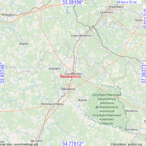
Balabanovo GPS coordinates[2]
55° 10' 53.796" North, 36° 39' 38.16" East
| Map corner | latitude | longitude |
|---|---|---|
| Upper-left | 55.58106°, | 35.95748° |
| Center: | 55.18161°, | 36.6606° |
| Lower-right: | 54.77812°, | 37.36373° |
| Map W x H: | 89.3×89.3 km | = 55.5×55.5mi |
| max Lat: | 73.50819° ⇑44.9% North |
| Balabanovo: | 55.18161° |
| min Lat: | ⇓55.1% South 41.28413° |
| min Long | Balabanovo | max Long |
| -179.12198° | 36.6606° | 179.35046° |
| W 14.1%⇐ | ⇒85.9% E |
Elevation
Elevation of Balabanovo is 160 m = 525 ft, and this is 42.6 m = 140 ft below average elevation for this country.
| Max E: |
2518 m = 8261 ft | 43.2% |
| Avg. | 202.6 m = 665 ft | |
| Balabanovo | 160 m = 525 ft | |
Min E: |
-28 m = -92 ft | 56.8% |
See also: Russia elevation on elevation.city.
Geographical zone
Balabanovo is located in North temperate zone (between Tropic of Cancer and the Arctic Circle). Distance of this North polar circle is 1265.6 km =786.4 mi to North.| Distance of | km | miles | from Balabanovo |
|---|---|---|---|
| North Pole | 3871.4 | 2405.6 | to North |
| Arctic Circle | 1265.6 | 786.4 | to North |
| Tropic Cancer | 3529.7 | 2193.3 | to South |
| Equator | 6135.6 | 3812.5 | to South |


Nearby cities:
15 places around Balabanovo: (largest is in red/bold)
• Ateptsevo
16.8 km =10.4 mi,  19°
19°
• Belousovo
9.7 km =6 mi,  175°
175°
• Borovsk
11.4 km =7.1 mi,  283°
283°
• Chupryakovo
41.3 km =25.7 mi,  357°
357°
• Kievskiy
30.5 km =19 mi,  25°
25°
• Kudinovo
32.9 km =20.4 mi,  231°
231°
• LMS
36.4 km =22.6 mi,  66°
66°
• Maloyaroslavets
22.1 km =13.7 mi,  212°
212°
• Naro-Fominsk
23.4 km =14.5 mi,  11°
11°
• Obninsk
10 km =6.2 mi,  198°
198°
• Panskoye
23.9 km =14.9 mi, 225°
• Vereya
35.9 km =22.3 mi,  300°
300°
• Vysokinichi
34.9 km =21.7 mi,  150°
150°
• Yermolino
4.4 km =2.7 mi,  289°
289°
• Zhukovo
17.5 km =10.9 mi,  162°
162°
Sources, notices
• [Note1] Compared only with cities in Russia existing in our database
• [Src1] Map data: © OpenStreetMap contributors (CC-BY-SA)
• [Src2] Other city data from geonames.org with taken over terms of usage.
• [Src3] Geographical zone / Annual Mean Temperature by Robert A. Rohde @ Wikipedia
