Zhukovo geodata
Zhukovo (Kaluga) is a populated place; located in Russia in Europe/Moscow (GMT+3) time zone. With population of 12,300 people, there are 1249 cities with bigger population in this country. Compared to other cities in Russia, 53.7% of cities are located further ↓South; 85.5% of cities are located further →East and 57.3% of cities have higher elevation than Zhukovo. Note1


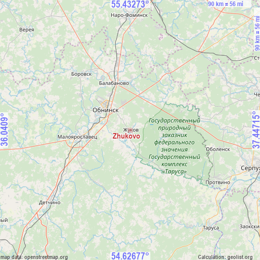
Zhukovo GPS coordinates[2]
55° 1' 54.408" North, 36° 44' 38.472" East
| Map corner | latitude | longitude |
|---|---|---|
| Upper-left | 55.43273°, | 36.0409° |
| Center: | 55.03178°, | 36.74402° |
| Lower-right: | 54.62677°, | 37.44715° |
| Map W x H: | 89.6×89.6 km | = 55.7×55.7mi |
| max Lat: | 73.50819° ⇑46.3% North |
| Zhukovo: | 55.03178° |
| min Lat: | ⇓53.7% South 41.28413° |
| min Long | Zhukovo | max Long |
| -179.12198° | 36.74402° | 179.35046° |
| W 14.5%⇐ | ⇒85.5% E |
Elevation
Elevation of Zhukovo is 130 m = 427 ft, and this is 72.6 m = 238 ft below average elevation for this country.
| Max E: |
2518 m = 8261 ft | 57.3% |
| Avg. | 202.6 m = 665 ft | |
| Zhukovo | 130 m = 427 ft | |
Min E: |
-28 m = -92 ft | 42.7% |
See also: Russia elevation on elevation.city.
Geographical zone
Zhukovo is located in North temperate zone (between Tropic of Cancer and the Arctic Circle). Distance of this North polar circle is 1282.2 km =796.7 mi to North.| Distance of | km | miles | from Zhukovo |
|---|---|---|---|
| North Pole | 3888.1 | 2416 | to North |
| Arctic Circle | 1282.2 | 796.7 | to North |
| Tropic Cancer | 3513 | 2182.9 | to South |
| Equator | 6119 | 3802.2 | to South |


Nearby cities:
15 places around Zhukovo: (largest is in red/bold)
• Ateptsevo
32.5 km =20.2 mi,  0°
0°
• Balabanovo
17.5 km =10.9 mi,  342°
342°
• Belousovo
8.4 km =5.2 mi,  327°
327°
• Borovsk
25.4 km =15.8 mi,  319°
319°
• Detchino
37.3 km =23.2 mi,  228°
228°
• Kremenki
28.9 km =18 mi,  124°
124°
• Kudinovo
31.5 km =19.6 mi,  263°
263°
• Maloyaroslavets
17.5 km =10.9 mi, 263°
• Obninsk
11.2 km =7 mi,  310°
310°
• Obolensk
31.2 km =19.4 mi,  101°
101°
• Panskoye
22.4 km =13.9 mi,  269°
269°
• Protvino
35.2 km =21.9 mi, 121°
• Raysemënovskoye
37.8 km =23.5 mi,  94°
94°
• Vysokinichi
18.1 km =11.2 mi,  138°
138°
• Yermolino
20.5 km =12.7 mi, 332°
Sources, notices
• [Note1] Compared only with cities in Russia existing in our database
• [Src1] Map data: © OpenStreetMap contributors (CC-BY-SA)
• [Src2] Other city data from geonames.org with taken over terms of usage.
• [Src3] Geographical zone / Annual Mean Temperature by Robert A. Rohde @ Wikipedia
