Belousovo geodata
Belousovo (Kaluga) is a populated place; located in Russia in Europe/Moscow (GMT+3) time zone. With population of 8,421 people, there are 1731 cities with bigger population in this country. Compared to other cities in Russia, 54.3% of cities are located further ↓South; 85.8% of cities are located further →East and 62.1% of cities have lower elevation than Belousovo. Note1


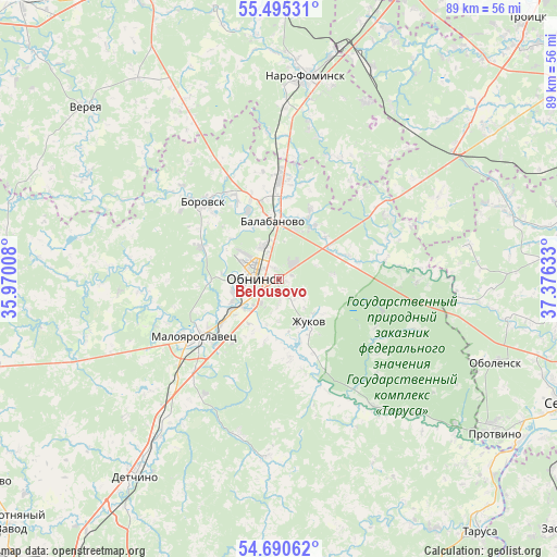
Belousovo GPS coordinates[2]
55° 5' 41.964" North, 36° 40' 23.52" East
| Map corner | latitude | longitude |
|---|---|---|
| Upper-left | 55.49531°, | 35.97008° |
| Center: | 55.09499°, | 36.6732° |
| Lower-right: | 54.69062°, | 37.37633° |
| Map W x H: | 89.5×89.5 km | = 55.6×55.6mi |
| max Lat: | 73.50819° ⇑45.7% North |
| Belousovo: | 55.09499° |
| min Lat: | ⇓54.3% South 41.28413° |
| min Long | Belousovo | max Long |
| -179.12198° | 36.6732° | 179.35046° |
| W 14.2%⇐ | ⇒85.8% E |
Elevation
Elevation of Belousovo is 174 m = 571 ft, and this is 28.6 m = 94 ft below average elevation for this country.
| Max E: |
2518 m = 8261 ft | 37.9% |
| Avg. | 202.6 m = 665 ft | |
| Belousovo | 174 m = 571 ft | |
Min E: |
-28 m = -92 ft | 62.1% |
See also: Russia elevation on elevation.city.
Geographical zone
Belousovo is located in North temperate zone (between Tropic of Cancer and the Arctic Circle). Distance of this North polar circle is 1275.2 km =792.4 mi to North.| Distance of | km | miles | from Belousovo |
|---|---|---|---|
| North Pole | 3881.1 | 2411.6 | to North |
| Arctic Circle | 1275.2 | 792.4 | to North |
| Tropic Cancer | 3520.1 | 2187.3 | to South |
| Equator | 6126 | 3806.5 | to South |


Nearby cities:
15 places around Belousovo: (largest is in red/bold)
• Ateptsevo
25.9 km =16.1 mi,  10°
10°
• Balabanovo
9.7 km =6 mi,  355°
355°
• Borovsk
17.2 km =10.7 mi,  316°
316°
• Detchino
39.4 km =24.5 mi,  216°
216°
• Kievskiy
39.2 km =24.4 mi,  18°
18°
• Kremenki
36.7 km =22.8 mi,  129°
129°
• Kudinovo
28.8 km =17.9 mi,  248°
248°
• Maloyaroslavets
15.6 km =9.7 mi,  235°
235°
• Naro-Fominsk
32.7 km =20.3 mi, 6°
• Obninsk
4 km =2.5 mi,  272°
272°
• Obolensk
37.5 km =23.3 mi,  110°
110°
• Panskoye
19.3 km =12 mi, 248°
• Vysokinichi
26.4 km =16.4 mi,  141°
141°
• Yermolino
12.2 km =7.6 mi,  335°
335°
• Zhukovo
8.4 km =5.2 mi,  147°
147°
Sources, notices
• [Note1] Compared only with cities in Russia existing in our database
• [Src1] Map data: © OpenStreetMap contributors (CC-BY-SA)
• [Src2] Other city data from geonames.org with taken over terms of usage.
• [Src3] Geographical zone / Annual Mean Temperature by Robert A. Rohde @ Wikipedia
