Burevestnik geodata
Burevestnik (Nizhny Novgorod Oblast) is a populated place; located in Russia in Europe/Moscow (GMT+3) time zone. With population of 3,054 people, there are 3739 cities with bigger population in this country. Compared to other cities in Russia, 68.5% of cities are located further ↓South; 53.5% of cities are located further →East and 72.6% of cities have higher elevation than Burevestnik. Note1


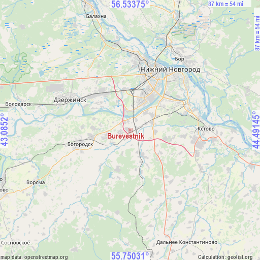
Burevestnik GPS coordinates[2]
56° 8' 38.508" North, 43° 47' 17.952" East
| Map corner | latitude | longitude |
|---|---|---|
| Upper-left | 56.53375°, | 43.0852° |
| Center: | 56.14403°, | 43.78832° |
| Lower-right: | 55.75031°, | 44.49145° |
| Map W x H: | 87.1×87.1 km | = 54.1×54.1mi |
| max Lat: | 73.50819° ⇑31.5% North |
| Burevestnik: | 56.14403° |
| min Lat: | ⇓68.5% South 41.28413° |
| min Long | Burevestnik | max Long |
| -179.12198° | 43.78832° | 179.35046° |
| W 46.5%⇐ | ⇒53.5% E |
Elevation
Elevation of Burevestnik is 95 m = 312 ft, and this is 107.6 m = 353 ft below average elevation for this country.
| Max E: |
2518 m = 8261 ft | 72.6% |
| Avg. | 202.6 m = 665 ft | |
| Burevestnik | 95 m = 312 ft | |
Min E: |
-28 m = -92 ft | 27.4% |
See also: Russia elevation on elevation.city.
Geographical zone
Burevestnik is located in North temperate zone (between Tropic of Cancer and the Arctic Circle). Distance of this North polar circle is 1158.5 km =719.9 mi to North.| Distance of | km | miles | from Burevestnik |
|---|---|---|---|
| North Pole | 3764.4 | 2339.1 | to North |
| Arctic Circle | 1158.5 | 719.9 | to North |
| Tropic Cancer | 3636.7 | 2259.7 | to South |
| Equator | 6242.6 | 3879 | to South |


Nearby cities:
15 places around Burevestnik: (largest is in red/bold)
• Afonino
23.1 km =14.4 mi,  55°
55°
• Babino
13.6 km =8.5 mi,  311°
311°
• Berëzovaya Poyma
24.1 km =15 mi,  333°
333°
• Bogorodsk
17.6 km =10.9 mi,  255°
255°
• Dzerzhinsk
23.3 km =14.5 mi,  297°
297°
• Gavrilovka
10.5 km =6.5 mi,  337°
337°
• Gorbatovka
12.9 km =8 mi,  348°
348°
• Kstovo
25.4 km =15.8 mi,  89°
89°
• Kuznechikha
21.2 km =13.2 mi,  46°
46°
• Lyakhovo
15.6 km =9.7 mi, 50°
• Nizhniy Novgorod
24.4 km =15.2 mi,  32°
32°
• Petryayevka
13.8 km =8.6 mi,  315°
315°
• Podnov’ye
26 km =16.2 mi, 46°
• Zelyony Gorod
18.1 km =11.2 mi,  77°
77°
• Zhelnino
27 km =16.8 mi,  283°
283°
Sources, notices
• [Note1] Compared only with cities in Russia existing in our database
• [Src1] Map data: © OpenStreetMap contributors (CC-BY-SA)
• [Src2] Other city data from geonames.org with taken over terms of usage.
• [Src3] Geographical zone / Annual Mean Temperature by Robert A. Rohde @ Wikipedia
