Azovskaya geodata
Azovskaya (Krasnodarskiy) is a populated place; located in Russia in Europe/Moscow (GMT+3) time zone. With population of 3,960 people, there are 3136 cities with bigger population in this country. Compared to other cities in Russia, 88.3% of cities are located further ↑North; 73.9% of cities are located further →East and 82% of cities have higher elevation than Azovskaya. Note1


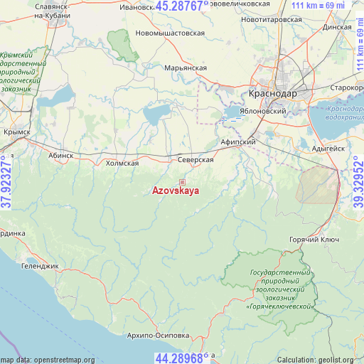
Azovskaya GPS coordinates[2]
44° 47' 26.988" North, 38° 37' 35.004" East
| Map corner | latitude | longitude |
|---|---|---|
| Upper-left | 45.28767°, | 37.92327° |
| Center: | 44.79083°, | 38.62639° |
| Lower-right: | 44.28968°, | 39.32952° |
| Map W x H: | 111×111 km | = 69×69mi |
| max Lat: | 73.50819° ⇑88.3% North |
| Azovskaya: | 44.79083° |
| min Lat: | ⇓11.7% South 41.28413° |
| min Long | Azovskaya | max Long |
| -179.12198° | 38.62639° | 179.35046° |
| W 26.1%⇐ | ⇒73.9% E |
Elevation
Elevation of Azovskaya is 63 m = 207 ft, and this is 139.6 m = 458 ft below average elevation for this country.
| Max E: |
2518 m = 8261 ft | 82% |
| Avg. | 202.6 m = 665 ft | |
| Azovskaya | 63 m = 207 ft | |
Min E: |
-28 m = -92 ft | 18% |
See also: Russia elevation on elevation.city.
Geographical zone
Azovskaya is located in North temperate zone (between Tropic of Cancer and the Arctic Circle). Distance of this Northern Tropic circle is 2374.4 km =1475.4 mi to South.| Distance of | km | miles | from Azovskaya |
|---|---|---|---|
| North Pole | 5026.8 | 3123.5 | to North |
| Arctic Circle | 2420.9 | 1504.3 | to North |
| Tropic Cancer | 2374.4 | 1475.4 | to South |
| Equator | 4980.3 | 3094.6 | to South |


Nearby cities:
15 places around Azovskaya: (largest is in red/bold)
• Abinsk
38 km =23.6 mi,  283°
283°
• Afipskiy
20.9 km =13 mi,  54°
54°
• Akhtyrskiy
26.5 km =16.5 mi,  285°
285°
• Belozërnyy
30.7 km =19.1 mi,  7°
7°
• Chernomorskiy
12.4 km =7.7 mi,  302°
302°
• Enem
26.7 km =16.6 mi,  55°
55°
• Il’skiy
7.4 km =4.6 mi,  320°
320°
• Kholmskiy
20 km =12.4 mi, 288°
• Krasnodar
39.4 km =24.5 mi,  44°
44°
• Novodmitriyevskaya
20.4 km =12.7 mi,  76°
76°
• Severskaya
8.1 km =5 mi,  29°
29°
• Smolenskaya
14 km =8.7 mi,  92°
92°
• Takhtamukay
32.5 km =20.2 mi, 63°
• Yablonovskiy
33.3 km =20.7 mi, 48°
• Yelizavetinskaya
31.3 km =19.4 mi, 25°
Sources, notices
• [Note1] Compared only with cities in Russia existing in our database
• [Src1] Map data: © OpenStreetMap contributors (CC-BY-SA)
• [Src2] Other city data from geonames.org with taken over terms of usage.
• [Src3] Geographical zone / Annual Mean Temperature by Robert A. Rohde @ Wikipedia
