Yablonovskiy geodata
Yablonovskiy (Adygeya Republic) is a populated place; located in Russia in Europe/Moscow (GMT+3) time zone. With population of 33,431 people, there are 597 cities with bigger population in this country. Compared to other cities in Russia, 87.5% of cities are located further ↑North; 72.4% of cities are located further →East and 93.3% of cities have higher elevation than Yablonovskiy. Note1


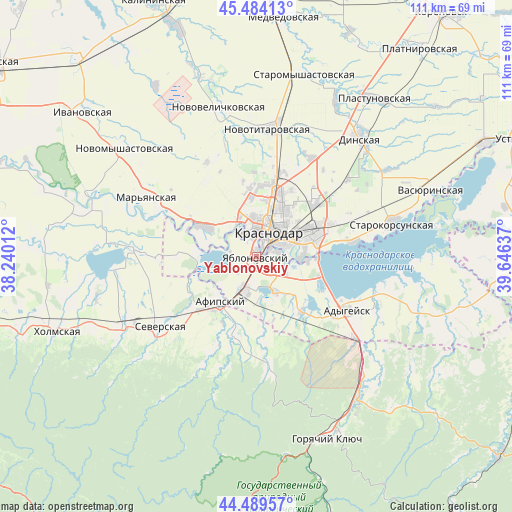
Yablonovskiy GPS coordinates[2]
44° 59' 20.436" North, 38° 56' 35.664" East
| Map corner | latitude | longitude |
|---|---|---|
| Upper-left | 45.48413°, | 38.24012° |
| Center: | 44.98901°, | 38.94324° |
| Lower-right: | 44.48957°, | 39.64637° |
| Map W x H: | 110.6×110.6 km | = 68.7×68.7mi |
| max Lat: | 73.50819° ⇑87.5% North |
| Yablonovskiy: | 44.98901° |
| min Lat: | ⇓12.5% South 41.28413° |
| min Long | Yablonovskiy | max Long |
| -179.12198° | 38.94324° | 179.35046° |
| W 27.6%⇐ | ⇒72.4% E |
Elevation
Elevation of Yablonovskiy is 17 m = 56 ft, and this is 185.6 m = 609 ft below average elevation for this country.
| Max E: |
2518 m = 8261 ft | 93.3% |
| Avg. | 202.6 m = 665 ft | |
| Yablonovskiy | 17 m = 56 ft | |
Min E: |
-28 m = -92 ft | 6.7% |
See also: Russia elevation on elevation.city.
Geographical zone
Yablonovskiy is located in North temperate zone (between Tropic of Cancer and the Arctic Circle). Distance of this Northern Tropic circle is 2396.4 km =1489.1 mi to South.| Distance of | km | miles | from Yablonovskiy |
|---|---|---|---|
| North Pole | 5004.8 | 3109.8 | to North |
| Arctic Circle | 2398.9 | 1490.6 | to North |
| Tropic Cancer | 2396.4 | 1489.1 | to South |
| Equator | 5002.3 | 3108.3 | to South |


Nearby cities:
15 places around Yablonovskiy: (largest is in red/bold)
• Adygeysk
22.7 km =14.1 mi,  120°
120°
• Afipskiy
12.7 km =7.9 mi,  218°
218°
• Agronom
25.9 km =16.1 mi,  49°
49°
• Belozërnyy
22.4 km =13.9 mi,  291°
291°
• Enem
7.6 km =4.7 mi,  202°
202°
• Krasnodar
6.7 km =4.2 mi,  22°
22°
• Novodmitriyevskaya
18.1 km =11.2 mi, 196°
• Novotitarovskaya
27.8 km =17.3 mi,  6°
6°
• Pashkovskiy
13.2 km =8.2 mi,  73°
73°
• Severskaya
25.8 km =16 mi,  234°
234°
• Smolenskaya
25.1 km =15.6 mi,  206°
206°
• Starokorsunskaya
30.3 km =18.8 mi,  75°
75°
• Takhtamukay
8.6 km =5.3 mi,  151°
151°
• Tlyustenkhabl’
12.2 km =7.6 mi,  93°
93°
• Yelizavetinskaya
13.3 km =8.3 mi,  298°
298°
Sources, notices
• [Note1] Compared only with cities in Russia existing in our database
• [Src1] Map data: © OpenStreetMap contributors (CC-BY-SA)
• [Src2] Other city data from geonames.org with taken over terms of usage.
• [Src3] Geographical zone / Annual Mean Temperature by Robert A. Rohde @ Wikipedia
