Ardab’yevo geodata
Ardab’yevo (Ryazan Oblast) is a populated place; located in Russia in Europe/Moscow (GMT+3) time zone. With population of 539 people, there are 4940 cities with bigger population in this country. Compared to other cities in Russia, 54.1% of cities are located further ↓South; 61% of cities are located further →East and 68.8% of cities have higher elevation than Ardab’yevo. Note1


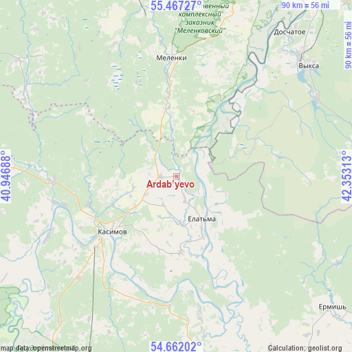
Ardab’yevo GPS coordinates[2]
55° 4' 0.012" North, 41° 39' 0" East
| Map corner | latitude | longitude |
|---|---|---|
| Upper-left | 55.46727°, | 40.94688° |
| Center: | 55.06667°, | 41.65° |
| Lower-right: | 54.66202°, | 42.35313° |
| Map W x H: | 89.5×89.5 km | = 55.6×55.6mi |
| max Lat: | 73.50819° ⇑45.9% North |
| Ardab’yevo: | 55.06667° |
| min Lat: | ⇓54.1% South 41.28413° |
| min Long | Ardab’yevo | max Long |
| -179.12198° | 41.65° | 179.35046° |
| W 39%⇐ | ⇒61% E |
Elevation
Elevation of Ardab’yevo is 105 m = 344 ft, and this is 97.6 m = 320 ft below average elevation for this country.
| Max E: |
2518 m = 8261 ft | 68.8% |
| Avg. | 202.6 m = 665 ft | |
| Ardab’yevo | 105 m = 344 ft | |
Min E: |
-28 m = -92 ft | 31.2% |
See also: Russia elevation on elevation.city.
Geographical zone
Ardab’yevo is located in North temperate zone (between Tropic of Cancer and the Arctic Circle). Distance of this North polar circle is 1278.3 km =794.3 mi to North.| Distance of | km | miles | from Ardab’yevo |
|---|---|---|---|
| North Pole | 3884.2 | 2413.5 | to North |
| Arctic Circle | 1278.3 | 794.3 | to North |
| Tropic Cancer | 3516.9 | 2185.3 | to South |
| Equator | 6122.8 | 3804.5 | to South |


Nearby cities:
15 places around Ardab’yevo: (largest is in red/bold)
• Blizhne-Pesochnoye
42.2 km =26.2 mi,  42°
42°
• Dobryatino
53.1 km =33 mi,  336°
336°
• Doschatoye
45.9 km =28.5 mi, 38°
• Gus’-Zheleznyy
30.9 km =19.2 mi,  268°
268°
• Kasimov
21.4 km =13.3 mi,  229°
229°
• Lashma
35.6 km =22.1 mi,  245°
245°
• Melenki
29.8 km =18.5 mi,  357°
357°
• Pitelino
55.4 km =34.4 mi,  169°
169°
• Shimorskoye
37.6 km =23.4 mi, 39°
• Syntul
23.6 km =14.7 mi, 252°
• Velet’ma
57.3 km =35.6 mi,  58°
58°
• Vilya
40.7 km =25.3 mi, 60°
• Vyksa
43.4 km =27 mi,  50°
50°
• Yelat’ma
12.8 km =8 mi,  149°
149°
• Yermish’
51.8 km =32.2 mi,  129°
129°
Sources, notices
• [Note1] Compared only with cities in Russia existing in our database
• [Src1] Map data: © OpenStreetMap contributors (CC-BY-SA)
• [Src2] Other city data from geonames.org with taken over terms of usage.
• [Src3] Geographical zone / Annual Mean Temperature by Robert A. Rohde @ Wikipedia
