Doschatoye geodata
Doschatoye (Nizhny Novgorod Oblast) is a populated place; located in Russia in Europe/Moscow (GMT+3) time zone. With population of 5,125 people, there are 2596 cities with bigger population in this country. Compared to other cities in Russia, 57.1% of cities are located further ↓South; 59.2% of cities are located further →East and 66.6% of cities have higher elevation than Doschatoye. Note1


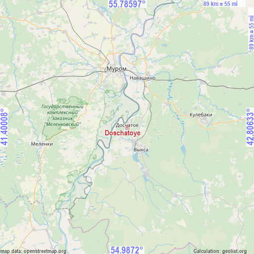
Doschatoye GPS coordinates[2]
55° 23' 18.96" North, 42° 6' 11.52" East
| Map corner | latitude | longitude |
|---|---|---|
| Upper-left | 55.78597°, | 41.40008° |
| Center: | 55.3886°, | 42.1032° |
| Lower-right: | 54.9872°, | 42.80633° |
| Map W x H: | 88.8×88.8 km | = 55.2×55.2mi |
| max Lat: | 73.50819° ⇑42.9% North |
| Doschatoye: | 55.3886° |
| min Lat: | ⇓57.1% South 41.28413° |
| min Long | Doschatoye | max Long |
| -179.12198° | 42.1032° | 179.35046° |
| W 40.8%⇐ | ⇒59.2% E |
Elevation
Elevation of Doschatoye is 110 m = 361 ft, and this is 92.6 m = 304 ft below average elevation for this country.
| Max E: |
2518 m = 8261 ft | 66.6% |
| Avg. | 202.6 m = 665 ft | |
| Doschatoye | 110 m = 361 ft | |
Min E: |
-28 m = -92 ft | 33.4% |
See also: Russia elevation on elevation.city.
Geographical zone
Doschatoye is located in North temperate zone (between Tropic of Cancer and the Arctic Circle). Distance of this North polar circle is 1242.5 km =772.1 mi to North.| Distance of | km | miles | from Doschatoye |
|---|---|---|---|
| North Pole | 3848.4 | 2391.3 | to North |
| Arctic Circle | 1242.5 | 772.1 | to North |
| Tropic Cancer | 3552.7 | 2207.5 | to South |
| Equator | 6158.6 | 3826.8 | to South |


Nearby cities:
15 places around Doschatoye: (largest is in red/bold)
• Ardab’yevo
45.9 km =28.5 mi,  218°
218°
• Blizhne-Pesochnoye
4.8 km =3 mi,  181°
181°
• Dobryatino
51.1 km =31.8 mi,  284°
284°
• Gremyachevo
58.4 km =36.3 mi,  89°
89°
• Krasnaya Gorbatka
57.6 km =35.8 mi,  338°
338°
• Kulebaki
27.2 km =16.9 mi,  84°
84°
• Melenki
30.5 km =19 mi,  258°
258°
• Murom
21.1 km =13.1 mi,  349°
349°
• Navashino
18.3 km =11.4 mi,  18°
18°
• Savasleyka
15.9 km =9.9 mi,  59°
59°
• Shimorskoye
8.3 km =5.2 mi, 216°
• Velet’ma
21 km =13 mi,  106°
106°
• Vilya
17.3 km =10.7 mi,  157°
157°
• Vyksa
9.1 km =5.7 mi,  150°
150°
• Yelat’ma
51.9 km =32.2 mi,  205°
205°
Sources, notices
• [Note1] Compared only with cities in Russia existing in our database
• [Src1] Map data: © OpenStreetMap contributors (CC-BY-SA)
• [Src2] Other city data from geonames.org with taken over terms of usage.
• [Src3] Geographical zone / Annual Mean Temperature by Robert A. Rohde @ Wikipedia
