Kuznechikha geodata
Kuznechikha (Nizhny Novgorod Oblast) is a populated place; located in Russia in Europe/Moscow (GMT+3) time zone. With population of 725 people, there are 4794 cities with bigger population in this country. Compared to other cities in Russia, 70.2% of cities are located further ↓South; 52.8% of cities are located further →East and 61.4% of cities have higher elevation than Kuznechikha. Note1
Administrative division(s):
- Level 1: Nizhny Novgorod Oblast
- Level 2: Nizhny Novgorod Urban Okrug
- Level 3: Sovetskiy Rayon


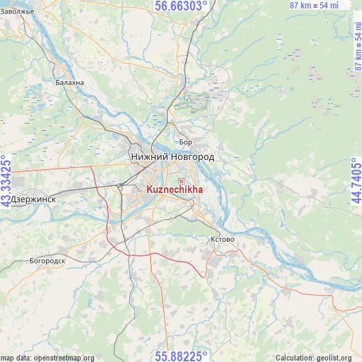
Kuznechikha GPS coordinates[2]
56° 16' 28.668" North, 44° 2' 14.532" East
| Map corner | latitude | longitude |
|---|---|---|
| Upper-left | 56.66303°, | 43.33425° |
| Center: | 56.27463°, | 44.03737° |
| Lower-right: | 55.88225°, | 44.7405° |
| Map W x H: | 86.8×86.8 km | = 53.9×53.9mi |
| max Lat: | 73.50819° ⇑29.8% North |
| Kuznechikha: | 56.27463° |
| min Lat: | ⇓70.2% South 41.28413° |
| min Long | Kuznechikha | max Long |
| -179.12198° | 44.03737° | 179.35046° |
| W 47.2%⇐ | ⇒52.8% E |
Elevation
Elevation of Kuznechikha is 121 m = 397 ft, and this is 81.6 m = 268 ft below average elevation for this country.
| Max E: |
2518 m = 8261 ft | 61.4% |
| Avg. | 202.6 m = 665 ft | |
| Kuznechikha | 121 m = 397 ft | |
Min E: |
-28 m = -92 ft | 38.6% |
See also: Russia elevation on elevation.city.
Geographical zone
Kuznechikha is located in North temperate zone (between Tropic of Cancer and the Arctic Circle). Distance of this North polar circle is 1144 km =710.8 mi to North.| Distance of | km | miles | from Kuznechikha |
|---|---|---|---|
| North Pole | 3749.9 | 2330.1 | to North |
| Arctic Circle | 1144 | 710.8 | to North |
| Tropic Cancer | 3651.2 | 2268.7 | to South |
| Equator | 6257.2 | 3888 | to South |


Nearby cities:
15 places around Kuznechikha: (largest is in red/bold)
• Afonino
3.8 km =2.4 mi,  111°
111°
• Bol’shoye Kozino
24.6 km =15.3 mi,  305°
305°
• Bor
9.6 km =6 mi,  13°
13°
• Burevestnik
21.2 km =13.2 mi,  226°
226°
• Gavrilovka
19.9 km =12.4 mi,  256°
256°
• Gorbatovka
18.1 km =11.2 mi, 263°
• Imeni M. I. Kalinina
21 km =13 mi,  120°
120°
• Kstovo
17.3 km =10.7 mi,  144°
144°
• Lyakhovo
5.7 km =3.5 mi,  216°
216°
• Neklyudovo
16 km =9.9 mi,  346°
346°
• Nizhniy Novgorod
6.4 km =4 mi,  340°
340°
• Petryayevka
25.4 km =15.8 mi, 259°
• Podnov’ye
4.9 km =3 mi,  44°
44°
• Sitniki
20.2 km =12.6 mi, 5°
• Zelyony Gorod
10.9 km =6.8 mi,  167°
167°
Sources, notices
• [Note1] Compared only with cities in Russia existing in our database
• [Src1] Map data: © OpenStreetMap contributors (CC-BY-SA)
• [Src2] Other city data from geonames.org with taken over terms of usage.
• [Src3] Geographical zone / Annual Mean Temperature by Robert A. Rohde @ Wikipedia
