Kstovo geodata
Kstovo (Nizhny Novgorod Oblast) is a populated place; located in Russia in Europe/Moscow (GMT+3) time zone. With population of 67,242 people, there are 303 cities with bigger population in this country. Compared to other cities in Russia, 68.6% of cities are located further ↓South; 52.3% of cities are located further →East and 58.6% of cities have higher elevation than Kstovo. Note1


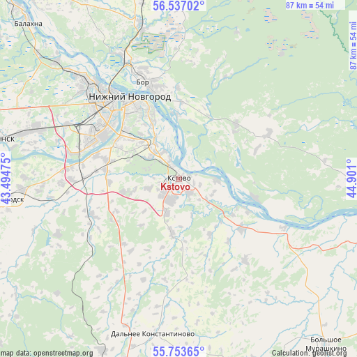
Kstovo GPS coordinates[2]
56° 8' 50.388" North, 44° 11' 52.332" East
| Map corner | latitude | longitude |
|---|---|---|
| Upper-left | 56.53702°, | 43.49475° |
| Center: | 56.14733°, | 44.19787° |
| Lower-right: | 55.75365°, | 44.901° |
| Map W x H: | 87.1×87.1 km | = 54.1×54.1mi |
| max Lat: | 73.50819° ⇑31.4% North |
| Kstovo: | 56.14733° |
| min Lat: | ⇓68.6% South 41.28413° |
| min Long | Kstovo | max Long |
| -179.12198° | 44.19787° | 179.35046° |
| W 47.7%⇐ | ⇒52.3% E |
Elevation
Elevation of Kstovo is 127 m = 417 ft, and this is 75.6 m = 248 ft below average elevation for this country.
| Max E: |
2518 m = 8261 ft | 58.6% |
| Avg. | 202.6 m = 665 ft | |
| Kstovo | 127 m = 417 ft | |
Min E: |
-28 m = -92 ft | 41.4% |
See also: Kstovo elevation on elevation.city.
Geographical zone
Kstovo is located in North temperate zone (between Tropic of Cancer and the Arctic Circle). Distance of this North polar circle is 1158.2 km =719.7 mi to North.| Distance of | km | miles | from Kstovo |
|---|---|---|---|
| North Pole | 3764.1 | 2338.9 | to North |
| Arctic Circle | 1158.2 | 719.7 | to North |
| Tropic Cancer | 3637.1 | 2260 | to South |
| Equator | 6243 | 3879.2 | to South |


Nearby cities:
15 places around Kstovo: (largest is in red/bold)
• Afonino
14.2 km =8.8 mi,  333°
333°
• Bor
24.6 km =15.3 mi,  342°
342°
• Burevestnik
25.4 km =15.8 mi,  269°
269°
• Gavrilovka
30.8 km =19.1 mi,  287°
287°
• Gorbatovka
30.5 km =19 mi, 293°
• Imeni M. I. Kalinina
9 km =5.6 mi,  66°
66°
• Kuznechikha
17.3 km =10.7 mi,  324°
324°
• Lyakhovo
16.4 km =10.2 mi,  305°
305°
• Neklyudovo
32.7 km =20.3 mi, 335°
• Nizhniy Novgorod
23.5 km =14.6 mi, 329°
• Pamyat’ Parizhskoy Kommuny
19 km =11.8 mi,  104°
104°
• Pervoye Maya
32.4 km =20.1 mi,  86°
86°
• Podnov’ye
18.8 km =11.7 mi, 339°
• Rabotki
27.7 km =17.2 mi,  115°
115°
• Zelyony Gorod
8.4 km =5.2 mi, 294°
Sources, notices
• [Note1] Compared only with cities in Russia existing in our database
• [Src1] Map data: © OpenStreetMap contributors (CC-BY-SA)
• [Src2] Other city data from geonames.org with taken over terms of usage.
• [Src3] Geographical zone / Annual Mean Temperature by Robert A. Rohde @ Wikipedia
