Yermakovskoye geodata
Yermakovskoye (Krasnoyarskiy) is a populated place; located in Russia in Asia/Krasnoyarsk (GMT+7) time zone. With population of 8,910 people, there are 1675 cities with bigger population in this country. Compared to other cities in Russia, 60.6% of cities are located further ↑North; 86.5% of cities are located further ←West and 83.8% of cities have lower elevation than Yermakovskoye. Note1


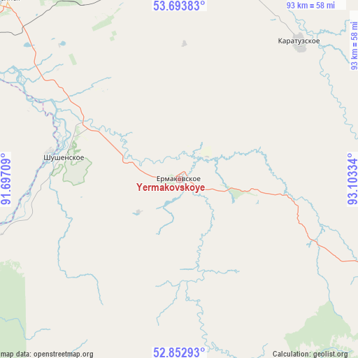
Yermakovskoye GPS coordinates[2]
53° 16' 31.62" North, 92° 24' 0.756" East
| Map corner | latitude | longitude |
|---|---|---|
| Upper-left | 53.69383°, | 91.69709° |
| Center: | 53.27545°, | 92.40021° |
| Lower-right: | 52.85293°, | 93.10334° |
| Map W x H: | 93.5×93.5 km | = 58.1×58.1mi |
| max Lat: | 73.50819° ⇑60.6% North |
| Yermakovskoye: | 53.27545° |
| min Lat: | ⇓39.4% South 41.28413° |
| min Long | Yermakovskoye | max Long |
| -179.12198° | 92.40021° | 179.35046° |
| W 86.5%⇐ | ⇒13.5% E |
Elevation
Elevation of Yermakovskoye is 298 m = 978 ft, and this is 95.4 m = 313 ft above average elevation for this country.
| Max E: |
2518 m = 8261 ft | 16.2% |
| Yermakovskoye | 298 m 978 ft | |
| Avg. | 202.6 m = 665 ft | |
Min E: |
-28 m = -92 ft | 83.8% |
See also: Russia elevation on elevation.city.
Geographical zone
Yermakovskoye is located in North temperate zone (between Tropic of Cancer and the Arctic Circle). Distance of this North polar circle is 1477.5 km =918.1 mi to North.| Distance of | km | miles | from Yermakovskoye |
|---|---|---|---|
| North Pole | 4083.4 | 2537.3 | to North |
| Arctic Circle | 1477.5 | 918.1 | to North |
| Tropic Cancer | 3317.8 | 2061.6 | to South |
| Equator | 5923.7 | 3680.8 | to South |


Nearby cities:
15 places around Yermakovskoye: (largest is in red/bold)
• Abakan
80.7 km =50.1 mi,  307°
307°
• Belyy Yar
76.2 km =47.3 mi,  298°
298°
• Chernogorsk
95.7 km =59.5 mi, 309°
• Cherëmushki
80.6 km =50.1 mi,  234°
234°
• Il’ichevo
37.2 km =23.1 mi,  270°
270°
• Karatuzskoye
48.1 km =29.9 mi,  39°
39°
• Kuragino
70.6 km =43.9 mi,  15°
15°
• Mayna
68.1 km =42.3 mi,  243°
243°
• Minusinsk
67.5 km =41.9 mi,  315°
315°
• Podsineye
71.8 km =44.6 mi, 307°
• Sayanogorsk
69.9 km =43.4 mi,  252°
252°
• Shushenskoye
31.4 km =19.5 mi,  280°
280°
• Tanzybey
39.5 km =24.5 mi,  113°
113°
• Ust’-Abakan
91.3 km =56.7 mi, 313°
• Zelënyy Bor
64.7 km =40.2 mi, 306°
Sources, notices
• [Note1] Compared only with cities in Russia existing in our database
• [Src1] Map data: © OpenStreetMap contributors (CC-BY-SA)
• [Src2] Other city data from geonames.org with taken over terms of usage.
• [Src3] Geographical zone / Annual Mean Temperature by Robert A. Rohde @ Wikipedia
