Mayna geodata
Mayna (Khakasiya Republic) is a populated place; located in Russia in Asia/Krasnoyarsk (GMT+7) time zone. With population of 5,287 people, there are 2515 cities with bigger population in this country. Compared to other cities in Russia, 62.7% of cities are located further ↑North; 86.2% of cities are located further ←West and 84.9% of cities have lower elevation than Mayna. Note1


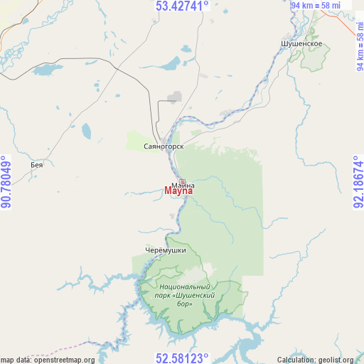
Mayna GPS coordinates[2]
53° 0' 23.004" North, 91° 29' 0.996" East
| Map corner | latitude | longitude |
|---|---|---|
| Upper-left | 53.42741°, | 90.78049° |
| Center: | 53.00639°, | 91.48361° |
| Lower-right: | 52.58123°, | 92.18674° |
| Map W x H: | 94.1×94.1 km | = 58.5×58.5mi |
| max Lat: | 73.50819° ⇑62.7% North |
| Mayna: | 53.00639° |
| min Lat: | ⇓37.3% South 41.28413° |
| min Long | Mayna | max Long |
| -179.12198° | 91.48361° | 179.35046° |
| W 86.2%⇐ | ⇒13.8% E |
Elevation
Elevation of Mayna is 317 m = 1040 ft, and this is 114.4 m = 375 ft above average elevation for this country.
| Max E: |
2518 m = 8261 ft | 15.1% |
| Mayna | 317 m 1040 ft | |
| Avg. | 202.6 m = 665 ft | |
Min E: |
-28 m = -92 ft | 84.9% |
See also: Russia elevation on elevation.city.
Geographical zone
Mayna is located in North temperate zone (between Tropic of Cancer and the Arctic Circle). Distance of this North polar circle is 1507.4 km =936.7 mi to North.| Distance of | km | miles | from Mayna |
|---|---|---|---|
| North Pole | 4113.3 | 2555.9 | to North |
| Arctic Circle | 1507.4 | 936.7 | to North |
| Tropic Cancer | 3287.8 | 2042.9 | to South |
| Equator | 5893.8 | 3662.2 | to South |


Nearby cities:
15 places around Mayna: (largest is in red/bold)
• Abakan
78.9 km =49 mi,  357°
357°
• Askiz
65.5 km =40.7 mi,  282°
282°
• Askiz
72 km =44.7 mi, 281°
• Belyy Yar
66.7 km =41.4 mi,  354°
354°
• Beya
38.5 km =23.9 mi, 277°
• Chernogorsk
91.8 km =57 mi, 351°
• Cherëmushki
17.3 km =10.7 mi,  194°
194°
• Il’ichevo
38.5 km =23.9 mi,  38°
38°
• Minusinsk
79.4 km =49.3 mi,  9°
9°
• Podsineye
73.4 km =45.6 mi,  2°
2°
• Sayanogorsk
10.6 km =6.6 mi,  328°
328°
• Shushenskoye
46.5 km =28.9 mi, 40°
• Ust’-Abakan
92.5 km =57.5 mi, 356°
• Yermakovskoye
68.1 km =42.3 mi,  63°
63°
• Zelënyy Bor
69 km =42.9 mi, 7°
Sources, notices
• [Note1] Compared only with cities in Russia existing in our database
• [Src1] Map data: © OpenStreetMap contributors (CC-BY-SA)
• [Src2] Other city data from geonames.org with taken over terms of usage.
• [Src3] Geographical zone / Annual Mean Temperature by Robert A. Rohde @ Wikipedia
