Zelënyy Bor geodata
Zelënyy Bor (Krasnoyarskiy) is a populated place; located in Russia in Asia/Krasnoyarsk (GMT+7) time zone. With population of 2,604 people, there are 3918 cities with bigger population in this country. Compared to other cities in Russia, 58% of cities are located further ↑North; 86.3% of cities are located further ←West and 81.6% of cities have lower elevation than Zelënyy Bor. Note1


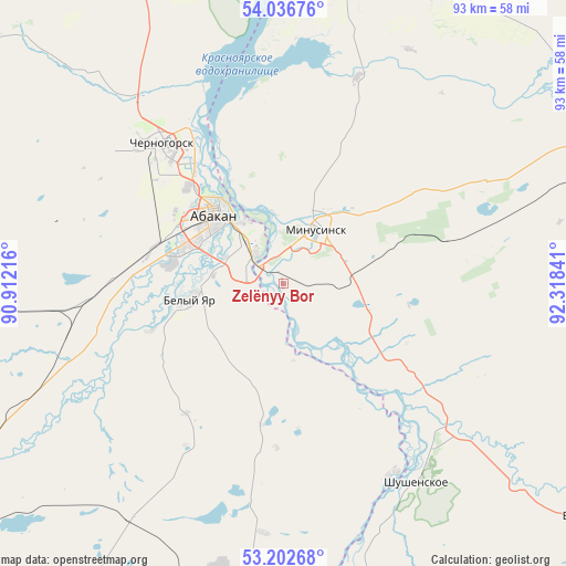
Zelënyy Bor GPS coordinates[2]
53° 37' 18.408" North, 91° 36' 55.008" East
| Map corner | latitude | longitude |
|---|---|---|
| Upper-left | 54.03676°, | 90.91216° |
| Center: | 53.62178°, | 91.61528° |
| Lower-right: | 53.20268°, | 92.31841° |
| Map W x H: | 92.7×92.7 km | = 57.6×57.6mi |
| max Lat: | 73.50819° ⇑58% North |
| Zelënyy Bor: | 53.62178° |
| min Lat: | ⇓42% South 41.28413° |
| min Long | Zelënyy Bor | max Long |
| -179.12198° | 91.61528° | 179.35046° |
| W 86.3%⇐ | ⇒13.7% E |
Elevation
Elevation of Zelënyy Bor is 269 m = 883 ft, and this is 66.4 m = 218 ft above average elevation for this country.
| Max E: |
2518 m = 8261 ft | 18.4% |
| Zelënyy Bor | 269 m 883 ft | |
| Avg. | 202.6 m = 665 ft | |
Min E: |
-28 m = -92 ft | 81.6% |
See also: Russia elevation on elevation.city.
Geographical zone
Zelënyy Bor is located in North temperate zone (between Tropic of Cancer and the Arctic Circle). Distance of this North polar circle is 1439 km =894.2 mi to North.| Distance of | km | miles | from Zelënyy Bor |
|---|---|---|---|
| North Pole | 4044.9 | 2513.4 | to North |
| Arctic Circle | 1439 | 894.2 | to North |
| Tropic Cancer | 3356.3 | 2085.5 | to South |
| Equator | 5962.2 | 3704.7 | to South |


Nearby cities:
15 places around Zelënyy Bor: (largest is in red/bold)
• Abakan
16.1 km =10 mi,  310°
310°
• Belyy Yar
15 km =9.3 mi,  262°
262°
• Beya
78.5 km =48.8 mi,  216°
216°
• Chernogorsk
31.3 km =19.4 mi,  315°
315°
• Il’ichevo
40.9 km =25.4 mi,  158°
158°
• Krasnoturansk
77.6 km =48.2 mi,  357°
357°
• Kuragino
76.1 km =47.3 mi,  67°
67°
• Mayna
69 km =42.9 mi,  187°
187°
• Minusinsk
10.9 km =6.8 mi,  25°
25°
• Podsineye
7.1 km =4.4 mi, 313°
• Sayanogorsk
61.1 km =38 mi, 193°
• Sayansk
61.3 km =38.1 mi,  16°
16°
• Shushenskoye
39.2 km =24.4 mi,  147°
147°
• Ust’-Abakan
28.1 km =17.5 mi,  328°
328°
• Yermakovskoye
64.7 km =40.2 mi,  126°
126°
Sources, notices
• [Note1] Compared only with cities in Russia existing in our database
• [Src1] Map data: © OpenStreetMap contributors (CC-BY-SA)
• [Src2] Other city data from geonames.org with taken over terms of usage.
• [Src3] Geographical zone / Annual Mean Temperature by Robert A. Rohde @ Wikipedia
