Tavatuy geodata
Tavatuy (Sverdlovsk) is a populated place; located in Russia in Asia/Yekaterinburg (GMT+5) time zone. With population of 559 people, there are 4927 cities with bigger population in this country. Compared to other cities in Russia, 78.3% of cities are located further ↓South; 72% of cities are located further ←West and 82.9% of cities have lower elevation than Tavatuy. Note1


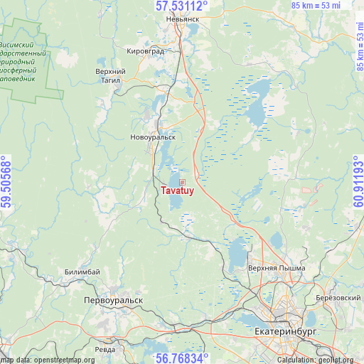
Tavatuy GPS coordinates[2]
57° 9' 6.12" North, 60° 12' 31.68" East
| Map corner | latitude | longitude |
|---|---|---|
| Upper-left | 57.53112°, | 59.50568° |
| Center: | 57.1517°, | 60.2088° |
| Lower-right: | 56.76834°, | 60.91193° |
| Map W x H: | 84.8×84.8 km | = 52.7×52.7mi |
| max Lat: | 73.50819° ⇑21.7% North |
| Tavatuy: | 57.1517° |
| min Lat: | ⇓78.3% South 41.28413° |
| min Long | Tavatuy | max Long |
| -179.12198° | 60.2088° | 179.35046° |
| W 72%⇐ | ⇒28% E |
Elevation
Elevation of Tavatuy is 284 m = 932 ft, and this is 81.4 m = 267 ft above average elevation for this country.
| Max E: |
2518 m = 8261 ft | 17.1% |
| Tavatuy | 284 m 932 ft | |
| Avg. | 202.6 m = 665 ft | |
Min E: |
-28 m = -92 ft | 82.9% |
See also: Russia elevation on elevation.city.
Geographical zone
Tavatuy is located in North temperate zone (between Tropic of Cancer and the Arctic Circle). Distance of this North polar circle is 1046.5 km =650.3 mi to North.| Distance of | km | miles | from Tavatuy |
|---|---|---|---|
| North Pole | 3652.4 | 2269.5 | to North |
| Arctic Circle | 1046.5 | 650.3 | to North |
| Tropic Cancer | 3748.8 | 2329.4 | to South |
| Equator | 6354.7 | 3948.6 | to South |


Nearby cities:
15 places around Tavatuy: (largest is in red/bold)
• Ayat’
13.2 km =8.2 mi,  173°
173°
• Bilimbay
31.3 km =19.4 mi,  229°
229°
• Iset’
21.7 km =13.5 mi,  152°
152°
• Kalinovo
4.4 km =2.7 mi,  239°
239°
• Kedrovoye
21.8 km =13.5 mi,  88°
88°
• Neyvo-Rudyanka
21.9 km =13.6 mi,  348°
348°
• Novoural’sk
12.7 km =7.9 mi,  323°
323°
• Pervoural’sk
31.8 km =19.8 mi,  210°
210°
• Severka
32 km =19.9 mi, 169°
• Shuvakish
30.6 km =19 mi, 147°
• Sredneuralsk
23.9 km =14.9 mi,  139°
139°
• Talitsa
32.2 km =20 mi,  200°
200°
• Verkh-Neyvinskiy
13.8 km =8.6 mi,  341°
341°
• Verkhniy Tagil
29 km =18 mi,  328°
328°
• Verkhnyaya Pyshma
30.3 km =18.8 mi,  131°
131°
Sources, notices
• [Note1] Compared only with cities in Russia existing in our database
• [Src1] Map data: © OpenStreetMap contributors (CC-BY-SA)
• [Src2] Other city data from geonames.org with taken over terms of usage.
• [Src3] Geographical zone / Annual Mean Temperature by Robert A. Rohde @ Wikipedia
