Sarasa geodata
Sarasa (Altai Krai) is a populated place; located in Russia in Asia/Barnaul (GMT+7) time zone. With population of 1,000 people, there are 4627 cities with bigger population in this country. Compared to other cities in Russia, 69.9% of cities are located further ↑North; 82.5% of cities are located further ←West and 85.6% of cities have lower elevation than Sarasa. Note1


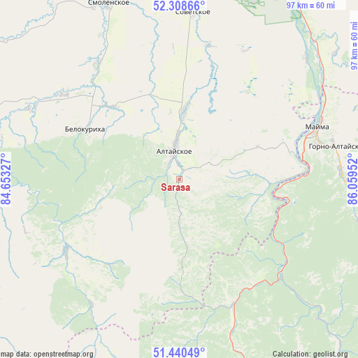
Sarasa GPS coordinates[2]
51° 52' 36.012" North, 85° 21' 23.004" East
| Map corner | latitude | longitude |
|---|---|---|
| Upper-left | 52.30866°, | 84.65327° |
| Center: | 51.87667°, | 85.35639° |
| Lower-right: | 51.44049°, | 86.05952° |
| Map W x H: | 96.5×96.5 km | = 60×60mi |
| max Lat: | 73.50819° ⇑69.9% North |
| Sarasa: | 51.87667° |
| min Lat: | ⇓30.1% South 41.28413° |
| min Long | Sarasa | max Long |
| -179.12198° | 85.35639° | 179.35046° |
| W 82.5%⇐ | ⇒17.5% E |
Elevation
Elevation of Sarasa is 334 m = 1096 ft, and this is 131.4 m = 431 ft above average elevation for this country.
| Max E: |
2518 m = 8261 ft | 14.4% |
| Sarasa | 334 m 1096 ft | |
| Avg. | 202.6 m = 665 ft | |
Min E: |
-28 m = -92 ft | 85.6% |
See also: Russia elevation on elevation.city.
Geographical zone
Sarasa is located in North temperate zone (between Tropic of Cancer and the Arctic Circle). Distance of this North polar circle is 1633 km =1014.7 mi to North.| Distance of | km | miles | from Sarasa |
|---|---|---|---|
| North Pole | 4238.9 | 2633.9 | to North |
| Arctic Circle | 1633 | 1014.7 | to North |
| Tropic Cancer | 3162.2 | 1964.9 | to South |
| Equator | 5768.1 | 3584.1 | to South |


Nearby cities:
15 places around Sarasa: (largest is in red/bold)
• Altayskoye
8.7 km =5.4 mi,  349°
349°
• Aya
31.5 km =19.6 mi,  75°
75°
• Belokurikha
28.4 km =17.6 mi,  297°
297°
• Cherga
37 km =23 mi,  157°
157°
• Gorno-Altaysk
39.7 km =24.7 mi, 76°
• Kamlak
35.1 km =21.8 mi,  143°
143°
• Manzherok
29.2 km =18.1 mi,  100°
100°
• Mayma
41 km =25.5 mi,  67°
67°
• Novotyryshkino
38.3 km =23.8 mi,  306°
306°
• Platovo
43.7 km =27.2 mi,  58°
58°
• Setovka
36.8 km =22.9 mi,  12°
12°
• Souzga
33.9 km =21.1 mi,  88°
88°
• Starobelokurikha
26.8 km =16.7 mi,  316°
316°
• Sychëvka
44.1 km =27.4 mi, 296°
• Половинка
37.6 km =23.4 mi,  21°
21°
Sources, notices
• [Note1] Compared only with cities in Russia existing in our database
• [Src1] Map data: © OpenStreetMap contributors (CC-BY-SA)
• [Src2] Other city data from geonames.org with taken over terms of usage.
• [Src3] Geographical zone / Annual Mean Temperature by Robert A. Rohde @ Wikipedia
