Ob’ geodata
Ob’ (Novosibirsk Oblast) is a populated place; located in Russia in Asia/Novosibirsk (GMT+7) time zone. With population of 24,238 people, there are 765 cities with bigger population in this country. Compared to other cities in Russia, 53.1% of cities are located further ↓South; 80.2% of cities are located further ←West and 67.7% of cities have higher elevation than Ob’. Note1


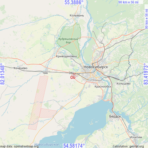
Ob’ GPS coordinates[2]
54° 59' 13.92" North, 82° 42' 59.76" East
| Map corner | latitude | longitude |
|---|---|---|
| Upper-left | 55.3886°, | 82.01348° |
| Center: | 54.9872°, | 82.7166° |
| Lower-right: | 54.58174°, | 83.41973° |
| Map W x H: | 89.7×89.7 km | = 55.7×55.7mi |
| max Lat: | 73.50819° ⇑46.9% North |
| Ob’: | 54.9872° |
| min Lat: | ⇓53.1% South 41.28413° |
| min Long | Ob’ | max Long |
| -179.12198° | 82.7166° | 179.35046° |
| W 80.2%⇐ | ⇒19.8% E |
Elevation
Elevation of Ob’ is 108 m = 354 ft, and this is 94.6 m = 310 ft below average elevation for this country.
| Max E: |
2518 m = 8261 ft | 67.7% |
| Avg. | 202.6 m = 665 ft | |
| Ob’ | 108 m = 354 ft | |
Min E: |
-28 m = -92 ft | 32.3% |
See also: Russia elevation on elevation.city.
Geographical zone
Ob’ is located in North temperate zone (between Tropic of Cancer and the Arctic Circle). Distance of this North polar circle is 1287.2 km =799.8 mi to North.| Distance of | km | miles | from Ob’ |
|---|---|---|---|
| North Pole | 3893.1 | 2419.1 | to North |
| Arctic Circle | 1287.2 | 799.8 | to North |
| Tropic Cancer | 3508.1 | 2179.8 | to South |
| Equator | 6114 | 3799.1 | to South |


Nearby cities:
15 places around Ob’: (largest is in red/bold)
• Akademgorodok
29.1 km =18.1 mi,  121°
121°
• Baryshevo
29.9 km =18.6 mi,  96°
96°
• Katkovo
18.5 km =11.5 mi,  323°
323°
• Kol’tsovo
30.2 km =18.8 mi, 100°
• Krasnoobsk
19 km =11.8 mi,  113°
113°
• Krivodanovka
11.9 km =7.4 mi,  340°
340°
• Kudryashovskiy
12.8 km =8 mi,  16°
16°
• Mochishche
32.1 km =19.9 mi,  53°
53°
• Novolugovoye
25.4 km =15.8 mi,  92°
92°
• Novosibirsk
15.2 km =9.4 mi,  66°
66°
• Prokudskoye
16.7 km =10.4 mi,  278°
278°
• Sadovyy
22.9 km =14.2 mi,  43°
43°
• Tolmachëvo
1.4 km =0.9 mi, 113°
• Verkh-Tula
12.1 km =7.5 mi,  161°
161°
• Yarkovo
21.5 km =13.4 mi,  200°
200°
Sources, notices
• [Note1] Compared only with cities in Russia existing in our database
• [Src1] Map data: © OpenStreetMap contributors (CC-BY-SA)
• [Src2] Other city data from geonames.org with taken over terms of usage.
• [Src3] Geographical zone / Annual Mean Temperature by Robert A. Rohde @ Wikipedia
