Kol’tsovo geodata
Kol’tsovo (Novosibirsk Oblast) is a populated place; located in Russia in Asia/Novosibirsk (GMT+7) time zone. With population of 9,976 people, there are 1516 cities with bigger population in this country. Compared to other cities in Russia, 52.6% of cities are located further ↓South; 80.6% of cities are located further ←West and 56.3% of cities have lower elevation than Kol’tsovo. Note1


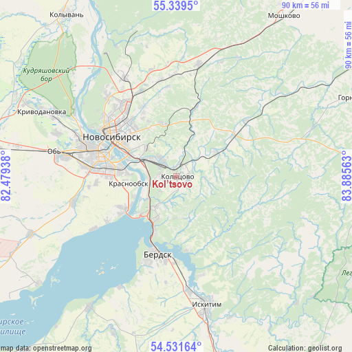
Kol’tsovo GPS coordinates[2]
54° 56' 15.36" North, 83° 10' 57" East
| Map corner | latitude | longitude |
|---|---|---|
| Upper-left | 55.3395°, | 82.47938° |
| Center: | 54.9376°, | 83.1825° |
| Lower-right: | 54.53164°, | 83.88563° |
| Map W x H: | 89.8×89.8 km | = 55.8×55.8mi |
| max Lat: | 73.50819° ⇑47.4% North |
| Kol’tsovo: | 54.9376° |
| min Lat: | ⇓52.6% South 41.28413° |
| min Long | Kol’tsovo | max Long |
| -179.12198° | 83.1825° | 179.35046° |
| W 80.6%⇐ | ⇒19.4% E |
Elevation
Elevation of Kol’tsovo is 159 m = 522 ft, and this is 43.6 m = 143 ft below average elevation for this country.
| Max E: |
2518 m = 8261 ft | 43.7% |
| Avg. | 202.6 m = 665 ft | |
| Kol’tsovo | 159 m = 522 ft | |
Min E: |
-28 m = -92 ft | 56.3% |
See also: Russia elevation on elevation.city.
Geographical zone
Kol’tsovo is located in North temperate zone (between Tropic of Cancer and the Arctic Circle). Distance of this North polar circle is 1292.7 km =803.2 mi to North.| Distance of | km | miles | from Kol’tsovo |
|---|---|---|---|
| North Pole | 3898.6 | 2422.5 | to North |
| Arctic Circle | 1292.7 | 803.2 | to North |
| Tropic Cancer | 3502.6 | 2176.4 | to South |
| Equator | 6108.5 | 3795.6 | to South |


Nearby cities:
15 places around Kol’tsovo: (largest is in red/bold)
• Akademgorodok
10.7 km =6.6 mi,  207°
207°
• Baryshevo
2.1 km =1.3 mi,  359°
359°
• Berdsk
21 km =13 mi,  195°
195°
• Iskitim
34.4 km =21.4 mi,  166°
166°
• Krasnoobsk
12.4 km =7.7 mi,  260°
260°
• Krivodanovka
37.6 km =23.4 mi,  296°
296°
• Kudryashovskiy
31.5 km =19.6 mi, 304°
• Mochishche
24.9 km =15.5 mi,  351°
351°
• Novolugovoye
6.4 km =4 mi,  316°
316°
• Novosibirsk
19.6 km =12.2 mi,  306°
306°
• Ob’
30.2 km =18.8 mi,  280°
280°
• Sadovyy
26 km =16.2 mi,  327°
327°
• Sokur
31.4 km =19.5 mi,  16°
16°
• Tolmachëvo
28.9 km =18 mi, 279°
• Verkh-Tula
26.6 km =16.5 mi, 257°
Sources, notices
• [Note1] Compared only with cities in Russia existing in our database
• [Src1] Map data: © OpenStreetMap contributors (CC-BY-SA)
• [Src2] Other city data from geonames.org with taken over terms of usage.
• [Src3] Geographical zone / Annual Mean Temperature by Robert A. Rohde @ Wikipedia
