Novolugovoye geodata
Novolugovoye (Novosibirsk Oblast) is a populated place; located in Russia in Asia/Novosibirsk (GMT+7) time zone. With population of 3,308 people, there are 3523 cities with bigger population in this country. Compared to other cities in Russia, 53% of cities are located further ↓South; 80.5% of cities are located further ←West and 66% of cities have higher elevation than Novolugovoye. Note1


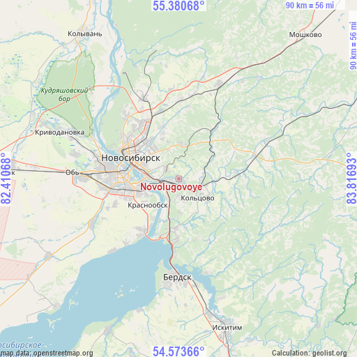
Novolugovoye GPS coordinates[2]
54° 58' 45.12" North, 83° 6' 49.68" East
| Map corner | latitude | longitude |
|---|---|---|
| Upper-left | 55.38068°, | 82.41068° |
| Center: | 54.9792°, | 83.1138° |
| Lower-right: | 54.57366°, | 83.81693° |
| Map W x H: | 89.7×89.7 km | = 55.7×55.7mi |
| max Lat: | 73.50819° ⇑47% North |
| Novolugovoye: | 54.9792° |
| min Lat: | ⇓53% South 41.28413° |
| min Long | Novolugovoye | max Long |
| -179.12198° | 83.1138° | 179.35046° |
| W 80.5%⇐ | ⇒19.5% E |
Elevation
Elevation of Novolugovoye is 111 m = 364 ft, and this is 91.6 m = 301 ft below average elevation for this country.
| Max E: |
2518 m = 8261 ft | 66% |
| Avg. | 202.6 m = 665 ft | |
| Novolugovoye | 111 m = 364 ft | |
Min E: |
-28 m = -92 ft | 34% |
See also: Russia elevation on elevation.city.
Geographical zone
Novolugovoye is located in North temperate zone (between Tropic of Cancer and the Arctic Circle). Distance of this North polar circle is 1288.1 km =800.4 mi to North.| Distance of | km | miles | from Novolugovoye |
|---|---|---|---|
| North Pole | 3893.9 | 2419.6 | to North |
| Arctic Circle | 1288.1 | 800.4 | to North |
| Tropic Cancer | 3507.2 | 2179.3 | to South |
| Equator | 6113.1 | 3798.5 | to South |


Nearby cities:
15 places around Novolugovoye: (largest is in red/bold)
• Akademgorodok
14.1 km =8.8 mi,  182°
182°
• Baryshevo
5 km =3.1 mi,  120°
120°
• Berdsk
24.9 km =15.5 mi, 182°
• Kol’tsovo
6.4 km =4 mi,  136°
136°
• Krasnoobsk
10.3 km =6.4 mi,  229°
229°
• Krivodanovka
31.6 km =19.6 mi,  292°
292°
• Kudryashovskiy
25.3 km =15.7 mi,  301°
301°
• Mochishche
20 km =12.4 mi,  1°
1°
• Novosibirsk
13.4 km =8.3 mi, 301°
• Ob’
25.4 km =15.8 mi,  272°
272°
• Sadovyy
19.8 km =12.3 mi,  331°
331°
• Sokur
28.7 km =17.8 mi,  27°
27°
• Tolmachëvo
24.1 km =15 mi, 270°
• Verkh-Tula
24 km =14.9 mi,  243°
243°
• Yarkovo
38.2 km =23.7 mi, 239°
Sources, notices
• [Note1] Compared only with cities in Russia existing in our database
• [Src1] Map data: © OpenStreetMap contributors (CC-BY-SA)
• [Src2] Other city data from geonames.org with taken over terms of usage.
• [Src3] Geographical zone / Annual Mean Temperature by Robert A. Rohde @ Wikipedia
