Kochenëvo geodata
Kochenëvo (Novosibirsk Oblast) is a populated place; located in Russia in Asia/Novosibirsk (GMT+7) time zone. With population of 16,446 people, there are 1019 cities with bigger population in this country. Compared to other cities in Russia, 53.5% of cities are located further ↓South; 79.9% of cities are located further ←West and 54.9% of cities have lower elevation than Kochenëvo. Note1


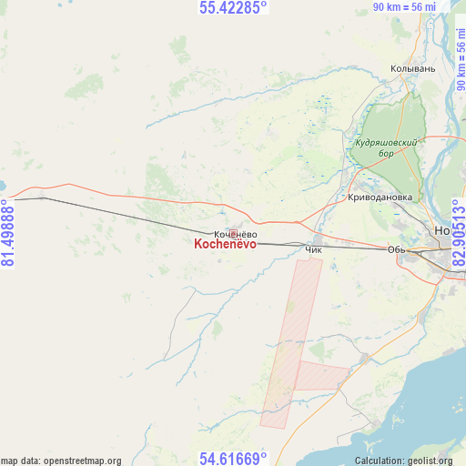
Kochenëvo GPS coordinates[2]
55° 1' 18.48" North, 82° 12' 7.2" East
| Map corner | latitude | longitude |
|---|---|---|
| Upper-left | 55.42285°, | 81.49888° |
| Center: | 55.0218°, | 82.202° |
| Lower-right: | 54.61669°, | 82.90513° |
| Map W x H: | 89.6×89.6 km | = 55.7×55.7mi |
| max Lat: | 73.50819° ⇑46.5% North |
| Kochenëvo: | 55.0218° |
| min Lat: | ⇓53.5% South 41.28413° |
| min Long | Kochenëvo | max Long |
| -179.12198° | 82.202° | 179.35046° |
| W 79.9%⇐ | ⇒20.1% E |
Elevation
Elevation of Kochenëvo is 156 m = 512 ft, and this is 46.6 m = 153 ft below average elevation for this country.
| Max E: |
2518 m = 8261 ft | 45.1% |
| Avg. | 202.6 m = 665 ft | |
| Kochenëvo | 156 m = 512 ft | |
Min E: |
-28 m = -92 ft | 54.9% |
See also: Russia elevation on elevation.city.
Geographical zone
Kochenëvo is located in North temperate zone (between Tropic of Cancer and the Arctic Circle). Distance of this North polar circle is 1283.3 km =797.4 mi to North.| Distance of | km | miles | from Kochenëvo |
|---|---|---|---|
| North Pole | 3889.2 | 2416.6 | to North |
| Arctic Circle | 1283.3 | 797.4 | to North |
| Tropic Cancer | 3511.9 | 2182.2 | to South |
| Equator | 6117.9 | 3801.5 | to South |


Nearby cities:
15 places around Kochenëvo: (largest is in red/bold)
• Bol’shoy Oyësh
43.5 km =27 mi,  47°
47°
• Katkovo
24.5 km =15.2 mi,  63°
63°
• Kolyvan’
46.4 km =28.8 mi, 47°
• Krasnoobsk
51.6 km =32.1 mi,  102°
102°
• Krivodanovka
29.8 km =18.5 mi,  75°
75°
• Kudryashovskiy
37.4 km =23.2 mi, 77°
• Mochishche
60.5 km =37.6 mi, 75°
• Novolugovoye
58.3 km =36.2 mi,  94°
94°
• Novosibirsk
46.7 km =29 mi, 87°
• Ob’
33 km =20.5 mi, 96°
• Prokudskoye
16.3 km =10.1 mi, 95°
• Sadovyy
50.3 km =31.3 mi, 75°
• Tolmachëvo
34.4 km =21.4 mi, 97°
• Verkh-Tula
39.7 km =24.7 mi,  112°
112°
• Yarkovo
34.9 km =21.7 mi,  133°
133°
Sources, notices
• [Note1] Compared only with cities in Russia existing in our database
• [Src1] Map data: © OpenStreetMap contributors (CC-BY-SA)
• [Src2] Other city data from geonames.org with taken over terms of usage.
• [Src3] Geographical zone / Annual Mean Temperature by Robert A. Rohde @ Wikipedia
