Borovskiy geodata
Borovskiy (Tyumen’ Oblast) is a populated place; located in Russia in Asia/Yekaterinburg (GMT+5) time zone. With population of 15,406 people, there are 1066 cities with bigger population in this country. Compared to other cities in Russia, 77.6% of cities are located further ↓South; 76.2% of cities are located further ←West and 83.4% of cities have higher elevation than Borovskiy. Note1


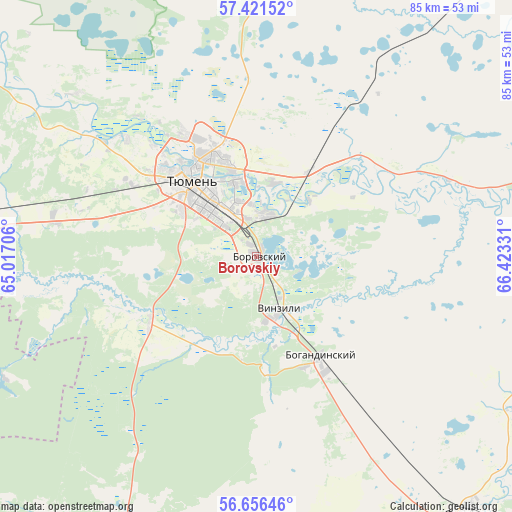
Borovskiy GPS coordinates[2]
57° 2' 27.456" North, 65° 43' 12.648" East
| Map corner | latitude | longitude |
|---|---|---|
| Upper-left | 57.42152°, | 65.01706° |
| Center: | 57.04096°, | 65.72018° |
| Lower-right: | 56.65646°, | 66.42331° |
| Map W x H: | 85.1×85.1 km | = 52.9×52.9mi |
| max Lat: | 73.50819° ⇑22.4% North |
| Borovskiy: | 57.04096° |
| min Lat: | ⇓77.6% South 41.28413° |
| min Long | Borovskiy | max Long |
| -179.12198° | 65.72018° | 179.35046° |
| W 76.2%⇐ | ⇒23.8% E |
Elevation
Elevation of Borovskiy is 56 m = 184 ft, and this is 146.6 m = 481 ft below average elevation for this country.
| Max E: |
2518 m = 8261 ft | 83.4% |
| Avg. | 202.6 m = 665 ft | |
| Borovskiy | 56 m = 184 ft | |
Min E: |
-28 m = -92 ft | 16.6% |
See also: Russia elevation on elevation.city.
Geographical zone
Borovskiy is located in North temperate zone (between Tropic of Cancer and the Arctic Circle). Distance of this North polar circle is 1058.8 km =657.9 mi to North.| Distance of | km | miles | from Borovskiy |
|---|---|---|---|
| North Pole | 3664.7 | 2277.1 | to North |
| Arctic Circle | 1058.8 | 657.9 | to North |
| Tropic Cancer | 3736.4 | 2321.7 | to South |
| Equator | 6342.4 | 3941 | to South |


Nearby cities:
15 places around Borovskiy: (largest is in red/bold)
• Antipino
7.7 km =4.8 mi,  17°
17°
• Bogandinskiy
19.5 km =12.1 mi,  147°
147°
• Chervishevo
20.6 km =12.8 mi,  239°
239°
• Isetskoye
66.3 km =41.2 mi,  201°
201°
• Lugovskoy
72.7 km =45.2 mi,  262°
262°
• Melioratorov
20.1 km =12.5 mi,  340°
340°
• Moskovskiy
19.6 km =12.2 mi,  293°
293°
• Nizhnyaya Tavda
75.3 km =46.8 mi, 21°
• Onokhino
16.9 km =10.5 mi,  220°
220°
• Tugulym
65.2 km =40.5 mi,  271°
271°
• Tyumen
17 km =10.6 mi,  316°
316°
• Vinzili
9.6 km =6 mi,  161°
161°
• Yalutorovsk
55.7 km =34.6 mi,  140°
140°
• Zavodoukovsk
78.3 km =48.7 mi, 139°
• Zavodouspenskoye
47.1 km =29.3 mi,  245°
245°
Sources, notices
• [Note1] Compared only with cities in Russia existing in our database
• [Src1] Map data: © OpenStreetMap contributors (CC-BY-SA)
• [Src2] Other city data from geonames.org with taken over terms of usage.
• [Src3] Geographical zone / Annual Mean Temperature by Robert A. Rohde @ Wikipedia
