Melioratorov geodata
Melioratorov (Tyumen’ Oblast) is a populated place; located in Russia in Asia/Yekaterinburg (GMT+5) time zone. With population of 5,306 people, there are 2507 cities with bigger population in this country. Compared to other cities in Russia, 78.5% of cities are located further ↓South; 76.1% of cities are located further ←West and 83% of cities have higher elevation than Melioratorov. Note1


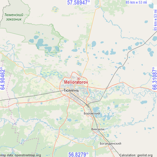
Melioratorov GPS coordinates[2]
57° 12' 38.34" North, 65° 36' 27.864" East
| Map corner | latitude | longitude |
|---|---|---|
| Upper-left | 57.58947°, | 64.90462° |
| Center: | 57.21065°, | 65.60774° |
| Lower-right: | 56.8279°, | 66.31087° |
| Map W x H: | 84.7×84.7 km | = 52.6×52.6mi |
| max Lat: | 73.50819° ⇑21.5% North |
| Melioratorov: | 57.21065° |
| min Lat: | ⇓78.5% South 41.28413° |
| min Long | Melioratorov | max Long |
| -179.12198° | 65.60774° | 179.35046° |
| W 76.1%⇐ | ⇒23.9% E |
Elevation
Elevation of Melioratorov is 58 m = 190 ft, and this is 144.6 m = 474 ft below average elevation for this country.
| Max E: |
2518 m = 8261 ft | 83% |
| Avg. | 202.6 m = 665 ft | |
| Melioratorov | 58 m = 190 ft | |
Min E: |
-28 m = -92 ft | 17% |
See also: Russia elevation on elevation.city.
Geographical zone
Melioratorov is located in North temperate zone (between Tropic of Cancer and the Arctic Circle). Distance of this North polar circle is 1039.9 km =646.2 mi to North.| Distance of | km | miles | from Melioratorov |
|---|---|---|---|
| North Pole | 3645.8 | 2265.4 | to North |
| Arctic Circle | 1039.9 | 646.2 | to North |
| Tropic Cancer | 3755.3 | 2333.4 | to South |
| Equator | 6361.2 | 3952.7 | to South |


Nearby cities:
15 places around Melioratorov: (largest is in red/bold)
• Antipino
14.7 km =9.1 mi,  141°
141°
• Bogandinskiy
39.3 km =24.4 mi,  153°
153°
• Borovskiy
20.1 km =12.5 mi,  160°
160°
• Chervishevo
31.3 km =19.4 mi,  200°
200°
• Isetskoye
82.4 km =51.2 mi,  192°
192°
• Lugovskoy
71 km =44.1 mi,  246°
246°
• Moskovskiy
15.7 km =9.8 mi,  225°
225°
• Nizhnyaya Tavda
61.5 km =38.2 mi,  33°
33°
• Onokhino
32 km =19.9 mi, 187°
• Tugulym
60.6 km =37.7 mi, 253°
• Tyumen
8.1 km =5 mi,  216°
216°
• Vinzili
29.6 km =18.4 mi, 160°
• Yalutorovsk
74.9 km =46.5 mi, 145°
• Yushala
82.7 km =51.4 mi,  259°
259°
• Zavodouspenskoye
52.7 km =32.7 mi, 222°
Sources, notices
• [Note1] Compared only with cities in Russia existing in our database
• [Src1] Map data: © OpenStreetMap contributors (CC-BY-SA)
• [Src2] Other city data from geonames.org with taken over terms of usage.
• [Src3] Geographical zone / Annual Mean Temperature by Robert A. Rohde @ Wikipedia
