Al Jubayl geodata
Al Jubayl (Eastern Province) is a populated place; located in Saudi Arabia in Asia/Riyadh (GMT+3) time zone. With population of 9,108 people, there are 71 cities with bigger population in this country. Compared to other cities in Saudi Arabia, 50.5% of cities are located further ↑North; 81.4% of cities are located further ←West and 61.9% of cities have higher elevation than Al Jubayl. Note1


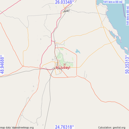
Al Jubayl GPS coordinates[2]
25° 24' 0" North, 49° 39' 0" East
| Map corner | latitude | longitude |
|---|---|---|
| Upper-left | 26.03348°, | 48.94688° |
| Center: | 25.4°, | 49.65° |
| Lower-right: | 24.76318°, | 50.35313° |
| Map W x H: | 141.2×141.2 km | = 87.7×87.7mi |
| max Lat: | 31.67252° ⇑50.5% North |
| Al Jubayl: | 25.4° |
| min Lat: | ⇓49.5% South 16.57946° |
| min Long | Al Jubayl | max Long |
| 35.69014° | 49.65° | 54.09599° |
| W 81.4%⇐ | ⇒18.6% E |
Elevation
Elevation of Al Jubayl is 140 m = 459 ft, and this is 381.4 m = 1251 ft below average elevation for this country.
| Max E: |
2385 m = 7825 ft | 61.9% |
| Avg. | 521.4 m = 1711 ft | |
| Al Jubayl | 140 m = 459 ft | |
Min E: |
3 m = 10 ft | 38.1% |
See also: Saudi Arabia elevation on elevation.city.
Geographical zone
Al Jubayl is located in North temperate zone (between Tropic of Cancer and the Arctic Circle). Distance of this Northern Tropic circle is 218.3 km =135.6 mi to South.| Distance of | km | miles | from Al Jubayl |
|---|---|---|---|
| North Pole | 7182.8 | 4463.2 | to North |
| Arctic Circle | 4577 | 2844 | to North |
| Tropic Cancer | 218.3 | 135.6 | to South |
| Equator | 2824.2 | 1754.9 | to South |


Nearby cities:
15 places around Al Jubayl: (largest is in red/bold)
• Abqaiq
59.4 km =36.9 mi,  1°
1°
• Al Baţţālīyah
4.1 km =2.5 mi,  335°
335°
• Al Hufūf
7.4 km =4.6 mi,  237°
237°
• Al Jafr
7.6 km =4.7 mi,  109°
109°
• Al Markaz
8.4 km =5.2 mi,  90°
90°
• Al Mubarraz
6.1 km =3.8 mi,  278°
278°
• Al Munayzilah
2.5 km =1.6 mi,  137°
137°
• Al Muţayrifī
12.7 km =7.9 mi,  313°
313°
• Al Qurayn
10.5 km =6.5 mi,  331°
331°
• Al Qārah
2.5 km =1.6 mi,  42°
42°
• Aţ Ţaraf
8.8 km =5.5 mi,  118°
118°
• Dammam
123.6 km =76.8 mi,  21°
21°
• Dhahran
109.2 km =67.9 mi,  25°
25°
• Julayjilah
12.2 km =7.6 mi, 335°
• Khobar
112.6 km =70 mi, 29°
Sources, notices
• [Note1] Compared only with cities in Saudi Arabia existing in our database
• [Src1] Map data: © OpenStreetMap contributors (CC-BY-SA)
• [Src2] Other city data from geonames.org with taken over terms of usage.
• [Src3] Geographical zone / Annual Mean Temperature by Robert A. Rohde @ Wikipedia
