Dhahran geodata
Dhahran (Eastern Province) is a populated place; located in Saudi Arabia in Asia/Riyadh (GMT+3) time zone. With population of 99,540 people, there are 24 cities with bigger population in this country. Compared to other cities in Saudi Arabia, 69.1% of cities are located further ↓South; 97.9% of cities are located further ←West and 76.3% of cities have higher elevation than Dhahran. Note1


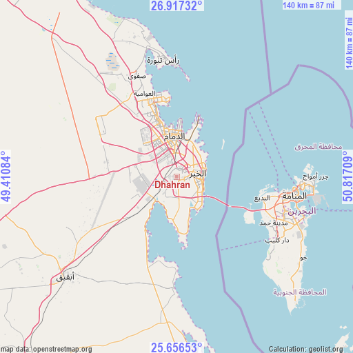
Dhahran GPS coordinates[2]
26° 17' 19.104" North, 50° 6' 50.256" East
| Map corner | latitude | longitude |
|---|---|---|
| Upper-left | 26.91732°, | 49.41084° |
| Center: | 26.28864°, | 50.11396° |
| Lower-right: | 25.65653°, | 50.81709° |
| Map W x H: | 140.2×140.2 km | = 87.1×87.1mi |
| max Lat: | 31.67252° ⇑30.9% North |
| Dhahran: | 26.28864° |
| min Lat: | ⇓69.1% South 16.57946° |
| min Long | Dhahran | max Long |
| 35.69014° | 50.11396° | 54.09599° |
| W 97.9%⇐ | ⇒2.1% E |
Elevation
Elevation of Dhahran is 44 m = 144 ft, and this is 477.4 m = 1566 ft below average elevation for this country.
| Max E: |
2385 m = 7825 ft | 76.3% |
| Avg. | 521.4 m = 1711 ft | |
| Dhahran | 44 m = 144 ft | |
Min E: |
3 m = 10 ft | 23.7% |
See also: Dhahran elevation on elevation.city.
Geographical zone
Dhahran is located in North temperate zone (between Tropic of Cancer and the Arctic Circle). Distance of this Northern Tropic circle is 317.1 km =197 mi to South.| Distance of | km | miles | from Dhahran |
|---|---|---|---|
| North Pole | 7084 | 4401.8 | to North |
| Arctic Circle | 4478.2 | 2782.6 | to North |
| Tropic Cancer | 317.1 | 197 | to South |
| Equator | 2923 | 1816.3 | to South |


Nearby cities:
15 places around Dhahran: (largest is in red/bold)
• Abqaiq
59.4 km =36.9 mi,  228°
228°
• Al Awjām
34.9 km =21.7 mi,  330°
330°
• Al Jubayl
94.6 km =58.8 mi, 328°
• Al Muţayrifī
105.8 km =65.7 mi,  211°
211°
• Al Qaţīf
32.5 km =20.2 mi,  341°
341°
• Al Qurayn
103.3 km =64.2 mi, 209°
• At Tūbī
32.3 km =20.1 mi, 337°
• Dammam
16.2 km =10.1 mi,  356°
356°
• Julayjilah
101.6 km =63.1 mi, 210°
• Khobar
9.5 km =5.9 mi,  96°
96°
• Raḩīmah
46.9 km =29.1 mi,  353°
353°
• Sayhāt
22.6 km =14 mi, 343°
• Tārūt
32.5 km =20.2 mi, 346°
• Umm as Sāhik
45.1 km =28 mi, 334°
• Şafwá
43.1 km =26.8 mi, 338°
Sources, notices
• [Note1] Compared only with cities in Saudi Arabia existing in our database
• [Src1] Map data: © OpenStreetMap contributors (CC-BY-SA)
• [Src2] Other city data from geonames.org with taken over terms of usage.
• [Src3] Geographical zone / Annual Mean Temperature by Robert A. Rohde @ Wikipedia
