Dammam geodata
Dammam (Eastern Province) is a seat of a first-order administrative division; located in Saudi Arabia in Asia/Riyadh (GMT+3) time zone. With population of 768,602 people, there are 5 cities with bigger population in this country. Compared to other cities in Saudi Arabia, 72.2% of cities are located further ↓South; 96.9% of cities are located further ←West and 88.7% of cities have higher elevation than Dammam. Note1


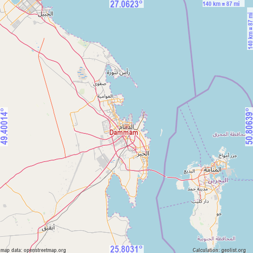
Dammam GPS coordinates[2]
26° 26' 3.912" North, 50° 6' 11.736" East
| Map corner | latitude | longitude |
|---|---|---|
| Upper-left | 27.0623°, | 49.40014° |
| Center: | 26.43442°, | 50.10326° |
| Lower-right: | 25.8031°, | 50.80639° |
| Map W x H: | 140×140 km | = 87×87mi |
| max Lat: | 31.67252° ⇑27.8% North |
| Dammam: | 26.43442° |
| min Lat: | ⇓72.2% South 16.57946° |
| min Long | Dammam | max Long |
| 35.69014° | 50.10326° | 54.09599° |
| W 96.9%⇐ | ⇒3.1% E |
Elevation
Elevation of Dammam is 10 m = 33 ft, and this is 511.4 m = 1678 ft below average elevation for this country.
| Max E: |
2385 m = 7825 ft | 88.7% |
| Avg. | 521.4 m = 1711 ft | |
| Dammam | 10 m = 33 ft | |
Min E: |
3 m = 10 ft | 11.3% |
See also: Dammam elevation on elevation.city.
Geographical zone
Dammam is located in North temperate zone (between Tropic of Cancer and the Arctic Circle). Distance of this Northern Tropic circle is 333.3 km =207.1 mi to South.| Distance of | km | miles | from Dammam |
|---|---|---|---|
| North Pole | 7067.8 | 4391.7 | to North |
| Arctic Circle | 4461.9 | 2772.5 | to North |
| Tropic Cancer | 333.3 | 207.1 | to South |
| Equator | 2939.2 | 1826.3 | to South |


Nearby cities:
15 places around Dammam: (largest is in red/bold)
• Abqaiq
70.5 km =43.8 mi,  217°
217°
• Al Awjām
21.4 km =13.3 mi,  311°
311°
• Al Jubayl
80.5 km =50 mi,  323°
323°
• Al Muţayrifī
119.4 km =74.2 mi,  207°
207°
• Al Qaţīf
17.3 km =10.7 mi,  327°
327°
• Al Qurayn
117.1 km =72.8 mi, 205°
• At Tūbī
17.6 km =10.9 mi, 321°
• Dhahran
16.2 km =10.1 mi,  176°
176°
• Julayjilah
115.4 km =71.7 mi, 205°
• Khobar
20.2 km =12.6 mi,  148°
148°
• Raḩīmah
30.7 km =19.1 mi,  352°
352°
• Sayhāt
7.7 km =4.8 mi, 314°
• Tārūt
16.7 km =10.4 mi,  337°
337°
• Umm as Sāhik
30.7 km =19.1 mi, 322°
• Şafwá
28.1 km =17.5 mi, 328°
Sources, notices
• [Note1] Compared only with cities in Saudi Arabia existing in our database
• [Src1] Map data: © OpenStreetMap contributors (CC-BY-SA)
• [Src2] Other city data from geonames.org with taken over terms of usage.
• [Src3] Geographical zone / Annual Mean Temperature by Robert A. Rohde @ Wikipedia
