Vinslöv geodata
Vinslöv (Skåne) is a populated place; located in Sweden in Europe/Stockholm (GMT+2) time zone. With population of 3,989 people, there are 321 cities with bigger population in this country. Compared to other cities in Sweden, 90.8% of cities are located further ↑North; 65.4% of cities are located further →East and 63.9% of cities have higher elevation than Vinslöv. Note1


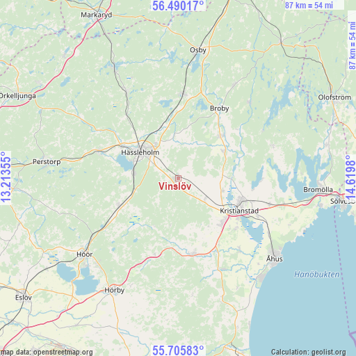
Vinslöv GPS coordinates[2]
56° 6' 0" North, 13° 55' 0.012" East
| Map corner | latitude | longitude |
|---|---|---|
| Upper-left | 56.49017°, | 13.21355° |
| Center: | 56.1°, | 13.91667° |
| Lower-right: | 55.70583°, | 14.6198° |
| Map W x H: | 87.2×87.2 km | = 54.2×54.2mi |
| max Lat: | 67.85572° ⇑90.8% North |
| Vinslöv: | 56.1° |
| min Lat: | ⇓9.2% South 55.34337° |
| min Long | Vinslöv | max Long |
| 11.1712° | 13.91667° | 24.13676° |
| W 34.6%⇐ | ⇒65.4% E |
Elevation
Elevation of Vinslöv is 31 m = 102 ft, and this is 51.6 m = 169 ft below average elevation for this country.
| Max E: |
663 m = 2175 ft | 63.9% |
| Avg. | 82.6 m = 271 ft | |
| Vinslöv | 31 m = 102 ft | |
Min E: |
-1 m = -3 ft | 36.1% |
See also: Sweden elevation on elevation.city.
Geographical zone
Vinslöv is located in North temperate zone (between Tropic of Cancer and the Arctic Circle). Distance of this North polar circle is 1163.4 km =722.9 mi to North.| Distance of | km | miles | from Vinslöv |
|---|---|---|---|
| North Pole | 3769.3 | 2342.1 | to North |
| Arctic Circle | 1163.4 | 722.9 | to North |
| Tropic Cancer | 3631.8 | 2256.7 | to South |
| Equator | 6237.7 | 3875.9 | to South |


Nearby cities:
15 places around Vinslöv: (largest is in red/bold)
• Arkelstorp
12.7 km =7.9 mi,  330°
330°
• Broby
19.9 km =12.4 mi,  30°
30°
• Finja
16.2 km =10.1 mi,  297°
297°
• Färlöv
11 km =6.8 mi,  109°
109°
• Hammarslund
19.5 km =12.1 mi,  117°
117°
• Hanaskog
12.8 km =8 mi,  58°
58°
• Hässleholm
11.4 km =7.1 mi,  305°
305°
• Knislinge
13.9 km =8.6 mi,  48°
48°
• Kristianstad
16.5 km =10.3 mi, 117°
• Norra Åsum
19.4 km =12.1 mi,  131°
131°
• Stoby
10.2 km =6.3 mi, 327°
• Sösdala
16.2 km =10.1 mi,  245°
245°
• Tollarp
19 km =11.8 mi,  167°
167°
• Tormestorp
10.7 km =6.6 mi,  278°
278°
• Önnestad
8.1 km =5 mi, 125°
Sources, notices
• [Note1] Compared only with cities in Sweden existing in our database
• [Src1] Map data: © OpenStreetMap contributors (CC-BY-SA)
• [Src2] Other city data from geonames.org with taken over terms of usage.
• [Src3] Geographical zone / Annual Mean Temperature by Robert A. Rohde @ Wikipedia
