Broby geodata
Broby (Skåne) is a seat of a second-order administrative division; located in Sweden in Europe/Stockholm (GMT+2) time zone. With population of 3,104 people, there are 397 cities with bigger population in this country. Compared to other cities in Sweden, 87.1% of cities are located further ↑North; 63.6% of cities are located further →East and 53% of cities have higher elevation than Broby. Note1


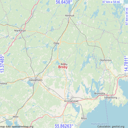
Broby GPS coordinates[2]
56° 15' 18.756" North, 14° 4' 40.692" East
| Map corner | latitude | longitude |
|---|---|---|
| Upper-left | 56.6438°, | 13.37485° |
| Center: | 56.25521°, | 14.07797° |
| Lower-right: | 55.86263°, | 14.7811° |
| Map W x H: | 86.9×86.9 km | = 54×54mi |
| max Lat: | 67.85572° ⇑87.1% North |
| Broby: | 56.25521° |
| min Lat: | ⇓12.9% South 55.34337° |
| min Long | Broby | max Long |
| 11.1712° | 14.07797° | 24.13676° |
| W 36.4%⇐ | ⇒63.6% E |
Elevation
Elevation of Broby is 45 m = 148 ft, and this is 37.6 m = 123 ft below average elevation for this country.
| Max E: |
663 m = 2175 ft | 53% |
| Avg. | 82.6 m = 271 ft | |
| Broby | 45 m = 148 ft | |
Min E: |
-1 m = -3 ft | 47% |
See also: Sweden elevation on elevation.city.
Geographical zone
Broby is located in North temperate zone (between Tropic of Cancer and the Arctic Circle). Distance of this North polar circle is 1146.2 km =712.2 mi to North.| Distance of | km | miles | from Broby |
|---|---|---|---|
| North Pole | 3752.1 | 2331.4 | to North |
| Arctic Circle | 1146.2 | 712.2 | to North |
| Tropic Cancer | 3649.1 | 2267.4 | to South |
| Equator | 6255 | 3886.7 | to South |


Nearby cities:
15 places around Broby: (largest is in red/bold)
• Arkelstorp
16.2 km =10.1 mi,  125°
125°
• Arkelstorp
17.3 km =10.7 mi,  249°
249°
• Färlöv
21 km =13 mi,  179°
179°
• Glimåkra
6 km =3.7 mi,  34°
34°
• Hanaskog
10.6 km =6.6 mi,  174°
174°
• Hittarp
3.9 km =2.4 mi,  37°
37°
• Hästveda
9.4 km =5.8 mi,  290°
290°
• Knislinge
8 km =5 mi, 177°
• Lönsboda
21.8 km =13.5 mi, 42°
• Osby
15 km =9.3 mi,  339°
339°
• Sibbhult
7.6 km =4.7 mi,  80°
80°
• Sjörröd
10.4 km =6.5 mi, 287°
• Stoby
17.7 km =11 mi,  240°
240°
• Tollarp1
16.1 km =10 mi, 127°
• Vinslöv
19.9 km =12.4 mi,  210°
210°
Sources, notices
• [Note1] Compared only with cities in Sweden existing in our database
• [Src1] Map data: © OpenStreetMap contributors (CC-BY-SA)
• [Src2] Other city data from geonames.org with taken over terms of usage.
• [Src3] Geographical zone / Annual Mean Temperature by Robert A. Rohde @ Wikipedia
