Hammarslund geodata
Hammarslund (Skåne) is a populated place; located in Sweden in Europe/Stockholm (GMT+2) time zone. With population of 587 people, there are 1190 cities with bigger population in this country. Compared to other cities in Sweden, 92.2% of cities are located further ↑North; 60.9% of cities are located further →East and 100% of cities have higher elevation than Hammarslund. Note1


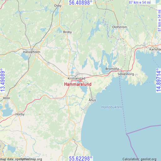
Hammarslund GPS coordinates[2]
56° 1' 4.728" North, 14° 11' 38.436" East
| Map corner | latitude | longitude |
|---|---|---|
| Upper-left | 56.40898°, | 13.49089° |
| Center: | 56.01798°, | 14.19401° |
| Lower-right: | 55.62298°, | 14.89714° |
| Map W x H: | 87.4×87.4 km | = 54.3×54.3mi |
| max Lat: | 67.85572° ⇑92.2% North |
| Hammarslund: | 56.01798° |
| min Lat: | ⇓7.8% South 55.34337° |
| min Long | Hammarslund | max Long |
| 11.1712° | 14.19401° | 24.13676° |
| W 39.1%⇐ | ⇒60.9% E |
Elevation
Elevation of Hammarslund is -1 m = -3 ft, and this is 83.6 m = 274 ft below average elevation for this country.
| Max E: |
663 m = 2175 ft | 100% |
| Avg. | 82.6 m = 271 ft | |
| Hammarslund | -1 m = -3 ft | |
Min E: |
-1 m = -3 ft | 0% |
See also: Sweden elevation on elevation.city.
Geographical zone
Hammarslund is located in North temperate zone (between Tropic of Cancer and the Arctic Circle). Distance of this North polar circle is 1172.6 km =728.6 mi to North.| Distance of | km | miles | from Hammarslund |
|---|---|---|---|
| North Pole | 3778.4 | 2347.8 | to North |
| Arctic Circle | 1172.6 | 728.6 | to North |
| Tropic Cancer | 3622.7 | 2251 | to South |
| Equator | 6228.6 | 3870.3 | to South |


Nearby cities:
15 places around Hammarslund: (largest is in red/bold)
• Everöd
14.4 km =8.9 mi,  204°
204°
• Fjälkinge
5.8 km =3.6 mi,  60°
60°
• Färlöv
8.8 km =5.5 mi,  308°
308°
• Gualöv
14.3 km =8.9 mi,  75°
75°
• Gärds Köpinge
9.8 km =6.1 mi, 196°
• Hammar
1.4 km =0.9 mi,  95°
95°
• Hanaskog
17.1 km =10.6 mi,  338°
338°
• Kristianstad
3 km =1.9 mi,  299°
299°
• Norra Åsum
4.7 km =2.9 mi,  215°
215°
• Rinkaby
5.9 km =3.7 mi,  130°
130°
• Tollarp
16.1 km =10 mi,  234°
234°
• Tollarp1
17.4 km =10.8 mi,  18°
18°
• Yngsjö
15.5 km =9.6 mi,  168°
168°
• Åhus
12.6 km =7.8 mi,  153°
153°
• Önnestad
11.5 km =7.1 mi,  292°
292°
Sources, notices
• [Note1] Compared only with cities in Sweden existing in our database
• [Src1] Map data: © OpenStreetMap contributors (CC-BY-SA)
• [Src2] Other city data from geonames.org with taken over terms of usage.
• [Src3] Geographical zone / Annual Mean Temperature by Robert A. Rohde @ Wikipedia
