Tumba geodata
Tumba (Stockholm) is a seat of a second-order administrative division; located in Sweden in Europe/Stockholm (GMT+2) time zone. With population of 40,832 people, there are 35 cities with bigger population in this country. Compared to other cities in Sweden, 56.7% of cities are located further ↓South; 83.2% of cities are located further ←West and 70% of cities have higher elevation than Tumba. Note1


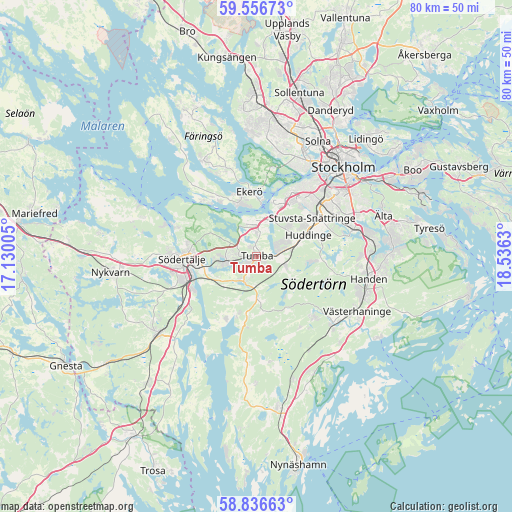
Tumba GPS coordinates[2]
59° 11' 54.888" North, 17° 49' 59.412" East
| Map corner | latitude | longitude |
|---|---|---|
| Upper-left | 59.55673°, | 17.13005° |
| Center: | 59.19858°, | 17.83317° |
| Lower-right: | 58.83663°, | 18.5363° |
| Map W x H: | 80.1×80.1 km | = 49.8×49.8mi |
| max Lat: | 67.85572° ⇑43.3% North |
| Tumba: | 59.19858° |
| min Lat: | ⇓56.7% South 55.34337° |
| min Long | Tumba | max Long |
| 11.1712° | 17.83317° | 24.13676° |
| W 83.2%⇐ | ⇒16.8% E |
Elevation
Elevation of Tumba is 25 m = 82 ft, and this is 57.6 m = 189 ft below average elevation for this country.
| Max E: |
663 m = 2175 ft | 70% |
| Avg. | 82.6 m = 271 ft | |
| Tumba | 25 m = 82 ft | |
Min E: |
-1 m = -3 ft | 30% |
See also: Tumba elevation on elevation.city.
Geographical zone
Tumba is located in North temperate zone (between Tropic of Cancer and the Arctic Circle). Distance of this North polar circle is 818.9 km =508.8 mi to North.| Distance of | km | miles | from Tumba |
|---|---|---|---|
| North Pole | 3424.8 | 2128.1 | to North |
| Arctic Circle | 818.9 | 508.8 | to North |
| Tropic Cancer | 3976.3 | 2470.8 | to South |
| Equator | 6582.3 | 4090.1 | to South |


Nearby cities:
15 places around Tumba: (largest is in red/bold)
• Alby
4.1 km =2.5 mi,  16°
16°
• Ekerö
10.3 km =6.4 mi,  353°
353°
• Eriksberg
5 km =3.1 mi, 348°
• Fittja
5.8 km =3.6 mi, 15°
• Huddinge
9.5 km =5.9 mi,  63°
63°
• Parksidan
9.2 km =5.7 mi,  5°
5°
• Pershagen
11.3 km =7 mi,  244°
244°
• Rönninge
5.7 km =3.5 mi,  271°
271°
• Segeltorp
10.2 km =6.3 mi,  32°
32°
• Södertälje
11.8 km =7.3 mi, 268°
• Tullinge
3.8 km =2.4 mi,  87°
87°
• Vidja
13.3 km =8.3 mi, 89°
• Vårby
8.1 km =5 mi, 20°
• Vårsta
4.2 km =2.6 mi,  208°
208°
• Älvnäs
10.2 km =6.3 mi,  338°
338°
Sources, notices
• [Note1] Compared only with cities in Sweden existing in our database
• [Src1] Map data: © OpenStreetMap contributors (CC-BY-SA)
• [Src2] Other city data from geonames.org with taken over terms of usage.
• [Src3] Geographical zone / Annual Mean Temperature by Robert A. Rohde @ Wikipedia
