Vårby geodata
Vårby (Stockholm) is a populated place; located in Sweden in Europe/Stockholm (GMT+2) time zone. With population of 10,115 people, there are 152 cities with bigger population in this country. Compared to other cities in Sweden, 58.8% of cities are located further ↓South; 84.2% of cities are located further ←West and 62.9% of cities have higher elevation than Vårby. Note1
Administrative division(s):
- Level 1: Stockholm
- Level 2: Huddinge Kommun
- Level 3: Huddinge
- Level 4: Huddinge socken


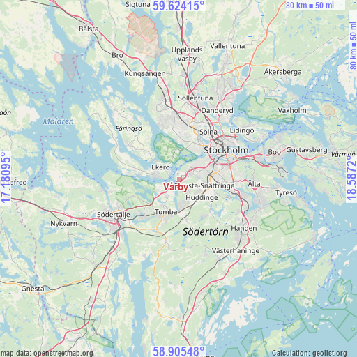
Vårby GPS coordinates[2]
59° 16' 0.156" North, 17° 53' 2.652" East
| Map corner | latitude | longitude |
|---|---|---|
| Upper-left | 59.62415°, | 17.18095° |
| Center: | 59.26671°, | 17.88407° |
| Lower-right: | 58.90548°, | 18.5872° |
| Map W x H: | 79.9×79.9 km | = 49.6×49.6mi |
| max Lat: | 67.85572° ⇑41.2% North |
| Vårby: | 59.26671° |
| min Lat: | ⇓58.8% South 55.34337° |
| min Long | Vårby | max Long |
| 11.1712° | 17.88407° | 24.13676° |
| W 84.2%⇐ | ⇒15.8% E |
Elevation
Elevation of Vårby is 32 m = 105 ft, and this is 50.6 m = 166 ft below average elevation for this country.
| Max E: |
663 m = 2175 ft | 62.9% |
| Avg. | 82.6 m = 271 ft | |
| Vårby | 32 m = 105 ft | |
Min E: |
-1 m = -3 ft | 37.1% |
See also: Sweden elevation on elevation.city.
Geographical zone
Vårby is located in North temperate zone (between Tropic of Cancer and the Arctic Circle). Distance of this North polar circle is 811.3 km =504.1 mi to North.| Distance of | km | miles | from Vårby |
|---|---|---|---|
| North Pole | 3417.2 | 2123.3 | to North |
| Arctic Circle | 811.3 | 504.1 | to North |
| Tropic Cancer | 3983.9 | 2475.5 | to South |
| Equator | 6589.8 | 4094.7 | to South |


Nearby cities:
15 places around Vårby: (largest is in red/bold)
• Alby
4.1 km =2.5 mi,  204°
204°
• Alvik
9.2 km =5.7 mi,  37°
37°
• Bromma
8.7 km =5.4 mi,  21°
21°
• Ekerö
4.9 km =3 mi,  303°
303°
• Eriksberg
4.7 km =2.9 mi,  234°
234°
• Fittja
2.4 km =1.5 mi,  214°
214°
• Huddinge
6.5 km =4 mi,  120°
120°
• Parksidan
2.6 km =1.6 mi,  307°
307°
• Rönninge
11.3 km =7 mi, 229°
• Segeltorp
2.8 km =1.7 mi,  68°
68°
• Tullinge
7.5 km =4.7 mi,  173°
173°
• Tumba
8.1 km =5 mi, 200°
• Tureholm
11 km =6.8 mi, 300°
• Älvnäs
6.9 km =4.3 mi,  285°
285°
• Årsta
10.1 km =6.3 mi, 70°
Sources, notices
• [Note1] Compared only with cities in Sweden existing in our database
• [Src1] Map data: © OpenStreetMap contributors (CC-BY-SA)
• [Src2] Other city data from geonames.org with taken over terms of usage.
• [Src3] Geographical zone / Annual Mean Temperature by Robert A. Rohde @ Wikipedia
