Fittja geodata
Fittja (Stockholm) is a populated place; located in Sweden in Europe/Stockholm (GMT+2) time zone. With population of 7,500 people, there are 194 cities with bigger population in this country. Compared to other cities in Sweden, 58.1% of cities are located further ↓South; 83.9% of cities are located further ←West and 63.9% of cities have higher elevation than Fittja. Note1


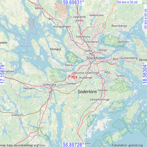
Fittja GPS coordinates[2]
59° 14' 55.248" North, 17° 51' 35.676" East
| Map corner | latitude | longitude |
|---|---|---|
| Upper-left | 59.60631°, | 17.15679° |
| Center: | 59.24868°, | 17.85991° |
| Lower-right: | 58.88726°, | 18.56304° |
| Map W x H: | 80×79.9 km | = 49.7×49.6mi |
| max Lat: | 67.85572° ⇑41.9% North |
| Fittja: | 59.24868° |
| min Lat: | ⇓58.1% South 55.34337° |
| min Long | Fittja | max Long |
| 11.1712° | 17.85991° | 24.13676° |
| W 83.9%⇐ | ⇒16.1% E |
Elevation
Elevation of Fittja is 31 m = 102 ft, and this is 51.6 m = 169 ft below average elevation for this country.
| Max E: |
663 m = 2175 ft | 63.9% |
| Avg. | 82.6 m = 271 ft | |
| Fittja | 31 m = 102 ft | |
Min E: |
-1 m = -3 ft | 36.1% |
See also: Sweden elevation on elevation.city.
Geographical zone
Fittja is located in North temperate zone (between Tropic of Cancer and the Arctic Circle). Distance of this North polar circle is 813.3 km =505.4 mi to North.| Distance of | km | miles | from Fittja |
|---|---|---|---|
| North Pole | 3419.2 | 2124.6 | to North |
| Arctic Circle | 813.3 | 505.4 | to North |
| Tropic Cancer | 3981.9 | 2474.2 | to South |
| Equator | 6587.8 | 4093.5 | to South |


Nearby cities:
15 places around Fittja: (largest is in red/bold)
• Alby
1.7 km =1.1 mi,  191°
191°
• Alvik
11.6 km =7.2 mi,  37°
37°
• Bromma
11.1 km =6.9 mi,  24°
24°
• Ekerö
5.4 km =3.4 mi,  330°
330°
• Eriksberg
2.6 km =1.6 mi,  254°
254°
• Huddinge
7.1 km =4.4 mi,  100°
100°
• Parksidan
3.6 km =2.2 mi,  349°
349°
• Rönninge
9 km =5.6 mi,  233°
233°
• Segeltorp
5 km =3.1 mi,  52°
52°
• Tullinge
5.9 km =3.7 mi,  157°
157°
• Tumba
5.8 km =3.6 mi,  195°
195°
• Tureholm
11.1 km =6.9 mi,  312°
312°
• Vårby
2.4 km =1.5 mi,  34°
34°
• Vårsta
9.9 km =6.2 mi, 201°
• Älvnäs
6.6 km =4.1 mi, 306°
Sources, notices
• [Note1] Compared only with cities in Sweden existing in our database
• [Src1] Map data: © OpenStreetMap contributors (CC-BY-SA)
• [Src2] Other city data from geonames.org with taken over terms of usage.
• [Src3] Geographical zone / Annual Mean Temperature by Robert A. Rohde @ Wikipedia
