Torsås geodata
Torsås (Kalmar) is a seat of a second-order administrative division; located in Sweden in Europe/Stockholm (GMT+2) time zone. With population of 2,000 people, there are 519 cities with bigger population in this country. Compared to other cities in Sweden, 85% of cities are located further ↑North; 61.9% of cities are located further ←West and 76.9% of cities have higher elevation than Torsås. Note1


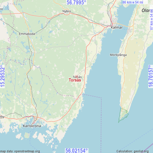
Torsås GPS coordinates[2]
56° 24' 45.036" North, 15° 59' 54.384" East
| Map corner | latitude | longitude |
|---|---|---|
| Upper-left | 56.7995°, | 15.29532° |
| Center: | 56.41251°, | 15.99844° |
| Lower-right: | 56.02154°, | 16.70157° |
| Map W x H: | 86.5×86.5 km | = 53.7×53.7mi |
| max Lat: | 67.85572° ⇑85% North |
| Torsås: | 56.41251° |
| min Lat: | ⇓15% South 55.34337° |
| min Long | Torsås | max Long |
| 11.1712° | 15.99844° | 24.13676° |
| W 61.9%⇐ | ⇒38.1% E |
Elevation
Elevation of Torsås is 18 m = 59 ft, and this is 64.6 m = 212 ft below average elevation for this country.
| Max E: |
663 m = 2175 ft | 76.9% |
| Avg. | 82.6 m = 271 ft | |
| Torsås | 18 m = 59 ft | |
Min E: |
-1 m = -3 ft | 23.1% |
See also: Sweden elevation on elevation.city.
Geographical zone
Torsås is located in North temperate zone (between Tropic of Cancer and the Arctic Circle). Distance of this North polar circle is 1128.7 km =701.3 mi to North.| Distance of | km | miles | from Torsås |
|---|---|---|---|
| North Pole | 3734.6 | 2320.6 | to North |
| Arctic Circle | 1128.7 | 701.3 | to North |
| Tropic Cancer | 3666.6 | 2278.3 | to South |
| Equator | 6272.5 | 3897.5 | to South |


Nearby cities:
15 places around Torsås: (largest is in red/bold)
• Bergkvara
5.2 km =3.2 mi,  118°
118°
• Fridlevstad
32.5 km =20.2 mi,  241°
241°
• Hagby
19.3 km =12 mi,  36°
36°
• Jämjö
26.4 km =16.4 mi,  201°
201°
• Ljungbyholm
26.6 km =16.5 mi,  22°
22°
• Mörbylånga
26.5 km =16.5 mi,  61°
61°
• Påryd
17.9 km =11.1 mi,  343°
343°
• Rinkabyholm
31.1 km =19.3 mi,  31°
31°
• Rödeby
28.7 km =17.8 mi,  234°
234°
• Smedby
32.7 km =20.3 mi, 27°
• Söderåkra
5.9 km =3.7 mi,  45°
45°
• Trekanten
32.8 km =20.4 mi,  12°
12°
• Tving
34.6 km =21.5 mi,  249°
249°
• Vassmolösa
23.3 km =14.5 mi, 26°
• Vissefjärda
28.8 km =17.9 mi,  297°
297°
Sources, notices
• [Note1] Compared only with cities in Sweden existing in our database
• [Src1] Map data: © OpenStreetMap contributors (CC-BY-SA)
• [Src2] Other city data from geonames.org with taken over terms of usage.
• [Src3] Geographical zone / Annual Mean Temperature by Robert A. Rohde @ Wikipedia
