Hagby geodata
Hagby (Kalmar) is a populated place; located in Sweden in Europe/Stockholm (GMT+2) time zone. With population of 871 people, there are 907 cities with bigger population in this country. Compared to other cities in Sweden, 83.1% of cities are located further ↑North; 63.8% of cities are located further ←West and 91.5% of cities have higher elevation than Hagby. Note1


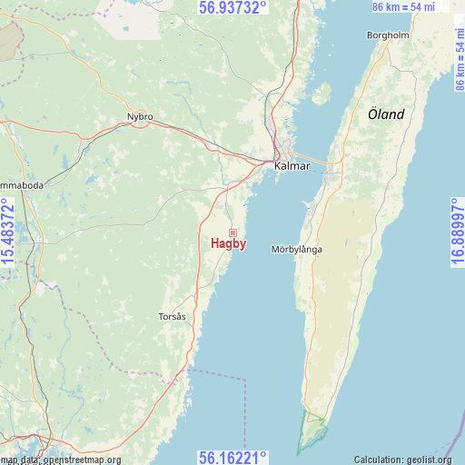
Hagby GPS coordinates[2]
56° 33' 6.3" North, 16° 11' 12.624" East
| Map corner | latitude | longitude |
|---|---|---|
| Upper-left | 56.93732°, | 15.48372° |
| Center: | 56.55175°, | 16.18684° |
| Lower-right: | 56.16221°, | 16.88997° |
| Map W x H: | 86.2×86.2 km | = 53.6×53.6mi |
| max Lat: | 67.85572° ⇑83.1% North |
| Hagby: | 56.55175° |
| min Lat: | ⇓16.9% South 55.34337° |
| min Long | Hagby | max Long |
| 11.1712° | 16.18684° | 24.13676° |
| W 63.8%⇐ | ⇒36.2% E |
Elevation
Elevation of Hagby is 8 m = 26 ft, and this is 74.6 m = 245 ft below average elevation for this country.
| Max E: |
663 m = 2175 ft | 91.5% |
| Avg. | 82.6 m = 271 ft | |
| Hagby | 8 m = 26 ft | |
Min E: |
-1 m = -3 ft | 8.5% |
See also: Sweden elevation on elevation.city.
Geographical zone
Hagby is located in North temperate zone (between Tropic of Cancer and the Arctic Circle). Distance of this North polar circle is 1113.2 km =691.7 mi to North.| Distance of | km | miles | from Hagby |
|---|---|---|---|
| North Pole | 3719.1 | 2310.9 | to North |
| Arctic Circle | 1113.2 | 691.7 | to North |
| Tropic Cancer | 3682 | 2287.9 | to South |
| Equator | 6288 | 3907.2 | to South |


Nearby cities:
15 places around Hagby: (largest is in red/bold)
• Algutsrum
25.4 km =15.8 mi,  54°
54°
• Bergkvara
19.2 km =11.9 mi,  201°
201°
• Färjestaden
20.4 km =12.7 mi,  57°
57°
• Kalmar
16.2 km =10.1 mi,  41°
41°
• Lindsdal
21.3 km =13.2 mi,  18°
18°
• Ljungbyholm
9.2 km =5.7 mi,  352°
352°
• Mörbylånga
12.1 km =7.5 mi,  104°
104°
• Påryd
16.6 km =10.3 mi,  275°
275°
• Rinkabyholm
11.9 km =7.4 mi, 24°
• Skogsby
22.6 km =14 mi,  65°
65°
• Smedby
14 km =8.7 mi,  14°
14°
• Söderåkra
13.5 km =8.4 mi,  213°
213°
• Torsås
19.3 km =12 mi,  216°
216°
• Trekanten
17 km =10.6 mi, 345°
• Vassmolösa
5.5 km =3.4 mi, 347°
Sources, notices
• [Note1] Compared only with cities in Sweden existing in our database
• [Src1] Map data: © OpenStreetMap contributors (CC-BY-SA)
• [Src2] Other city data from geonames.org with taken over terms of usage.
• [Src3] Geographical zone / Annual Mean Temperature by Robert A. Rohde @ Wikipedia
