Stora Mellösa geodata
Stora Mellösa (Örebro) is a populated place; located in Sweden in Europe/Stockholm (GMT+2) time zone. With population of 801 people, there are 964 cities with bigger population in this country. Compared to other cities in Sweden, 57.2% of cities are located further ↓South; 55.3% of cities are located further ←West and 62.9% of cities have higher elevation than Stora Mellösa. Note1


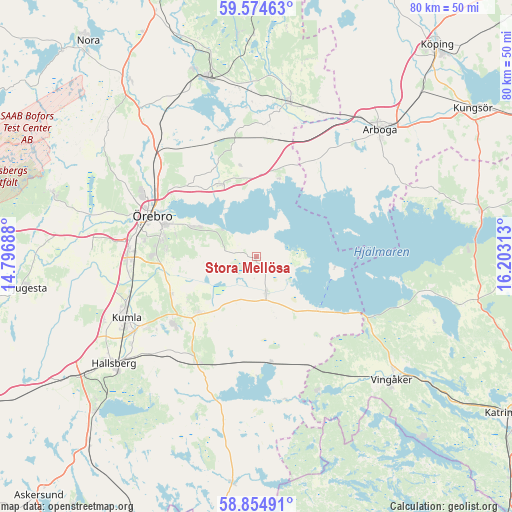
Stora Mellösa GPS coordinates[2]
59° 13' 0.012" North, 15° 30' 0" East
| Map corner | latitude | longitude |
|---|---|---|
| Upper-left | 59.57463°, | 14.79688° |
| Center: | 59.21667°, | 15.5° |
| Lower-right: | 58.85491°, | 16.20313° |
| Map W x H: | 80×80 km | = 49.7×49.7mi |
| max Lat: | 67.85572° ⇑42.8% North |
| Stora Mellösa: | 59.21667° |
| min Lat: | ⇓57.2% South 55.34337° |
| min Long | Stora Mellösa | max Long |
| 11.1712° | 15.5° | 24.13676° |
| W 55.3%⇐ | ⇒44.7% E |
Elevation
Elevation of Stora Mellösa is 32 m = 105 ft, and this is 50.6 m = 166 ft below average elevation for this country.
| Max E: |
663 m = 2175 ft | 62.9% |
| Avg. | 82.6 m = 271 ft | |
| Stora Mellösa | 32 m = 105 ft | |
Min E: |
-1 m = -3 ft | 37.1% |
See also: Sweden elevation on elevation.city.
Geographical zone
Stora Mellösa is located in North temperate zone (between Tropic of Cancer and the Arctic Circle). Distance of this North polar circle is 816.9 km =507.6 mi to North.| Distance of | km | miles | from Stora Mellösa |
|---|---|---|---|
| North Pole | 3422.8 | 2126.8 | to North |
| Arctic Circle | 816.9 | 507.6 | to North |
| Tropic Cancer | 3978.4 | 2472.1 | to South |
| Equator | 6584.3 | 4091.3 | to South |


Nearby cities:
15 places around Stora Mellösa: (largest is in red/bold)
• Ekeby-Almby
10.8 km =6.7 mi,  296°
296°
• Fellingsbro
24.5 km =15.2 mi,  11°
11°
• Glanshammar
12.5 km =7.8 mi,  332°
332°
• Hovsta
21.9 km =13.6 mi,  312°
312°
• Hällabrottet
20.4 km =12.7 mi,  236°
236°
• Högsjö
23.2 km =14.4 mi,  155°
155°
• Kumla
22.6 km =14 mi, 244°
• Mellösa
1.9 km =1.2 mi,  180°
180°
• Mosås
21 km =13 mi,  264°
264°
• Norra Bro
14.2 km =8.8 mi,  270°
270°
• Odensbacken
5.9 km =3.7 mi, 161°
• Pålsboda
19.2 km =11.9 mi,  208°
208°
• Sköllersta
12.7 km =7.9 mi,  226°
226°
• Ölmbrotorp
24.4 km =15.2 mi,  323°
323°
• Örebro
17.9 km =11.1 mi,  290°
290°
Sources, notices
• [Note1] Compared only with cities in Sweden existing in our database
• [Src1] Map data: © OpenStreetMap contributors (CC-BY-SA)
• [Src2] Other city data from geonames.org with taken over terms of usage.
• [Src3] Geographical zone / Annual Mean Temperature by Robert A. Rohde @ Wikipedia
