Ronneby geodata
Ronneby (Blekinge) is a seat of a second-order administrative division; located in Sweden in Europe/Stockholm (GMT+2) time zone. With population of 12,612 people, there are 124 cities with bigger population in this country. Compared to other cities in Sweden, 87.7% of cities are located further ↑North; 53% of cities are located further ←West and 95.4% of cities have higher elevation than Ronneby. Note1


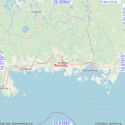
Ronneby GPS coordinates[2]
56° 12' 35.964" North, 15° 16' 33.672" East
| Map corner | latitude | longitude |
|---|---|---|
| Upper-left | 56.59904°, | 14.5729° |
| Center: | 56.20999°, | 15.27602° |
| Lower-right: | 55.81695°, | 15.97915° |
| Map W x H: | 87×87 km | = 54.1×54.1mi |
| max Lat: | 67.85572° ⇑87.7% North |
| Ronneby: | 56.20999° |
| min Lat: | ⇓12.3% South 55.34337° |
| min Long | Ronneby | max Long |
| 11.1712° | 15.27602° | 24.13676° |
| W 53%⇐ | ⇒47% E |
Elevation
Elevation of Ronneby is 5 m = 16 ft, and this is 77.6 m = 255 ft below average elevation for this country.
| Max E: |
663 m = 2175 ft | 95.4% |
| Avg. | 82.6 m = 271 ft | |
| Ronneby | 5 m = 16 ft | |
Min E: |
-1 m = -3 ft | 4.6% |
See also: Sweden elevation on elevation.city.
Geographical zone
Ronneby is located in North temperate zone (between Tropic of Cancer and the Arctic Circle). Distance of this North polar circle is 1151.2 km =715.3 mi to North.| Distance of | km | miles | from Ronneby |
|---|---|---|---|
| North Pole | 3757.1 | 2334.6 | to North |
| Arctic Circle | 1151.2 | 715.3 | to North |
| Tropic Cancer | 3644 | 2264.3 | to South |
| Equator | 6250 | 3883.6 | to South |


Nearby cities:
15 places around Ronneby: (largest is in red/bold)
• Bräkne-Hoby
10.2 km =6.3 mi,  284°
284°
• Fridlevstad
17.4 km =10.8 mi,  66°
66°
• Hasslö
16.5 km =10.3 mi,  128°
128°
• Hällaryd
20.2 km =12.6 mi,  266°
266°
• Johannishus
8.7 km =5.4 mi,  85°
85°
• Kallinge
4.3 km =2.7 mi,  9°
9°
• Karlshamn
26 km =16.2 mi,  260°
260°
• Karlskrona
20 km =12.4 mi,  105°
105°
• Listerby
7.7 km =4.8 mi,  98°
98°
• Nättraby
14.9 km =9.3 mi, 94°
• Ronnebyhamn
3.3 km =2.1 mi,  153°
153°
• Rödeby
22.1 km =13.7 mi,  75°
75°
• Skavkulla
15.2 km =9.4 mi, 101°
• Sturkö
29.8 km =18.5 mi,  118°
118°
• Tving
16.1 km =10 mi,  48°
48°
Sources, notices
• [Note1] Compared only with cities in Sweden existing in our database
• [Src1] Map data: © OpenStreetMap contributors (CC-BY-SA)
• [Src2] Other city data from geonames.org with taken over terms of usage.
• [Src3] Geographical zone / Annual Mean Temperature by Robert A. Rohde @ Wikipedia
