Bräkne-Hoby geodata
Bräkne-Hoby (Blekinge) is a populated place; located in Sweden in Europe/Stockholm (GMT+2) time zone. With population of 1,708 people, there are 592 cities with bigger population in this country. Compared to other cities in Sweden, 87.5% of cities are located further ↑North; 51.1% of cities are located further ←West and 63.9% of cities have higher elevation than Bräkne-Hoby. Note1


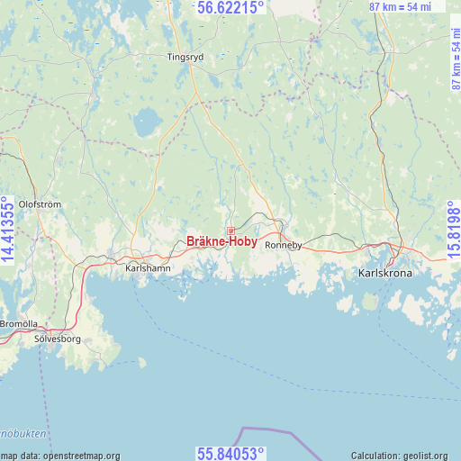
Bräkne-Hoby GPS coordinates[2]
56° 13' 59.988" North, 15° 7' 0.012" East
| Map corner | latitude | longitude |
|---|---|---|
| Upper-left | 56.62215°, | 14.41355° |
| Center: | 56.23333°, | 15.11667° |
| Lower-right: | 55.84053°, | 15.8198° |
| Map W x H: | 86.9×86.9 km | = 54×54mi |
| max Lat: | 67.85572° ⇑87.5% North |
| Bräkne-Hoby: | 56.23333° |
| min Lat: | ⇓12.5% South 55.34337° |
| min Long | Bräkne-Hoby | max Long |
| 11.1712° | 15.11667° | 24.13676° |
| W 51.1%⇐ | ⇒48.9% E |
Elevation
Elevation of Bräkne-Hoby is 31 m = 102 ft, and this is 51.6 m = 169 ft below average elevation for this country.
| Max E: |
663 m = 2175 ft | 63.9% |
| Avg. | 82.6 m = 271 ft | |
| Bräkne-Hoby | 31 m = 102 ft | |
Min E: |
-1 m = -3 ft | 36.1% |
See also: Sweden elevation on elevation.city.
Geographical zone
Bräkne-Hoby is located in North temperate zone (between Tropic of Cancer and the Arctic Circle). Distance of this North polar circle is 1148.6 km =713.7 mi to North.| Distance of | km | miles | from Bräkne-Hoby |
|---|---|---|---|
| North Pole | 3754.5 | 2332.9 | to North |
| Arctic Circle | 1148.6 | 713.7 | to North |
| Tropic Cancer | 3646.6 | 2265.9 | to South |
| Equator | 6252.6 | 3885.2 | to South |


Nearby cities:
15 places around Bräkne-Hoby: (largest is in red/bold)
• Fridlevstad
26.2 km =16.3 mi,  80°
80°
• Hasslö
26.1 km =16.2 mi,  119°
119°
• Hällaryd
11 km =6.8 mi,  250°
250°
• Johannishus
18.6 km =11.6 mi,  95°
95°
• Kallinge
10.7 km =6.6 mi, 80°
• Karlshamn
17.2 km =10.7 mi, 246°
• Karlskrona
30.1 km =18.7 mi,  105°
105°
• Listerby
17.9 km =11.1 mi, 101°
• Mörrum
23.3 km =14.5 mi,  258°
258°
• Nättraby
25 km =15.5 mi, 98°
• Ronneby
10.2 km =6.3 mi, 104°
• Ronnebyhamn
12.6 km =7.8 mi, 116°
• Skavkulla
25.4 km =15.8 mi, 102°
• Svängsta
21.9 km =13.6 mi,  279°
279°
• Tving
23.3 km =14.5 mi,  69°
69°
Sources, notices
• [Note1] Compared only with cities in Sweden existing in our database
• [Src1] Map data: © OpenStreetMap contributors (CC-BY-SA)
• [Src2] Other city data from geonames.org with taken over terms of usage.
• [Src3] Geographical zone / Annual Mean Temperature by Robert A. Rohde @ Wikipedia
