Johannishus geodata
Johannishus (Blekinge) is a populated place; located in Sweden in Europe/Stockholm (GMT+2) time zone. With population of 766 people, there are 1000 cities with bigger population in this country. Compared to other cities in Sweden, 87.6% of cities are located further ↑North; 54.6% of cities are located further ←West and 62.2% of cities have higher elevation than Johannishus. Note1


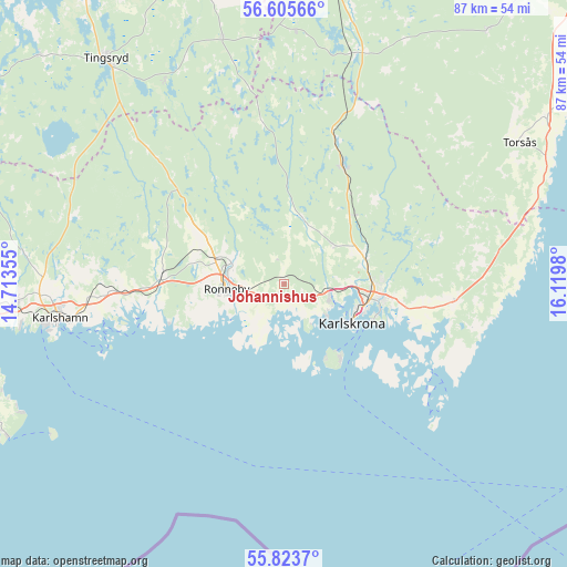
Johannishus GPS coordinates[2]
56° 13' 0.012" North, 15° 25' 0.012" East
| Map corner | latitude | longitude |
|---|---|---|
| Upper-left | 56.60566°, | 14.71355° |
| Center: | 56.21667°, | 15.41667° |
| Lower-right: | 55.8237°, | 16.1198° |
| Map W x H: | 86.9×86.9 km | = 54×54mi |
| max Lat: | 67.85572° ⇑87.6% North |
| Johannishus: | 56.21667° |
| min Lat: | ⇓12.4% South 55.34337° |
| min Long | Johannishus | max Long |
| 11.1712° | 15.41667° | 24.13676° |
| W 54.6%⇐ | ⇒45.4% E |
Elevation
Elevation of Johannishus is 33 m = 108 ft, and this is 49.6 m = 163 ft below average elevation for this country.
| Max E: |
663 m = 2175 ft | 62.2% |
| Avg. | 82.6 m = 271 ft | |
| Johannishus | 33 m = 108 ft | |
Min E: |
-1 m = -3 ft | 37.8% |
See also: Sweden elevation on elevation.city.
Geographical zone
Johannishus is located in North temperate zone (between Tropic of Cancer and the Arctic Circle). Distance of this North polar circle is 1150.5 km =714.9 mi to North.| Distance of | km | miles | from Johannishus |
|---|---|---|---|
| North Pole | 3756.4 | 2334.1 | to North |
| Arctic Circle | 1150.5 | 714.9 | to North |
| Tropic Cancer | 3644.8 | 2264.8 | to South |
| Equator | 6250.7 | 3884 | to South |


Nearby cities:
15 places around Johannishus: (largest is in red/bold)
• Bräkne-Hoby
18.6 km =11.6 mi,  275°
275°
• Fridlevstad
9.6 km =6 mi,  49°
49°
• Hasslö
11.9 km =7.4 mi,  159°
159°
• Jämjö
26.4 km =16.4 mi,  95°
95°
• Kallinge
8.7 km =5.4 mi,  293°
293°
• Karlskrona
12.2 km =7.6 mi,  120°
120°
• Listerby
2.1 km =1.3 mi,  209°
209°
• Nättraby
6.5 km =4 mi,  106°
106°
• Ronneby
8.7 km =5.4 mi,  265°
265°
• Ronnebyhamn
8.1 km =5 mi,  242°
242°
• Rödeby
13.6 km =8.5 mi,  68°
68°
• Skavkulla
7.2 km =4.5 mi, 120°
• Sturkö
23 km =14.3 mi,  130°
130°
• Torhamn
28.9 km =18 mi, 116°
• Tving
10.4 km =6.5 mi,  18°
18°
Sources, notices
• [Note1] Compared only with cities in Sweden existing in our database
• [Src1] Map data: © OpenStreetMap contributors (CC-BY-SA)
• [Src2] Other city data from geonames.org with taken over terms of usage.
• [Src3] Geographical zone / Annual Mean Temperature by Robert A. Rohde @ Wikipedia
