Rindö geodata
Rindö (Stockholm) is a populated place; located in Sweden in Europe/Stockholm (GMT+2) time zone. With population of 1,100 people, there are 769 cities with bigger population in this country. Compared to other cities in Sweden, 63.6% of cities are located further ↓South; 90% of cities are located further ←West and 60.3% of cities have higher elevation than Rindö. Note1


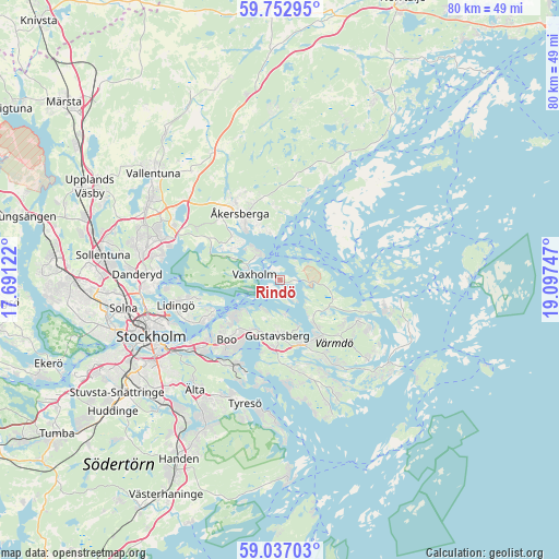
Rindö GPS coordinates[2]
59° 23' 48.768" North, 18° 23' 39.624" East
| Map corner | latitude | longitude |
|---|---|---|
| Upper-left | 59.75295°, | 17.69122° |
| Center: | 59.39688°, | 18.39434° |
| Lower-right: | 59.03703°, | 19.09747° |
| Map W x H: | 79.6×79.6 km | = 49.5×49.5mi |
| max Lat: | 67.85572° ⇑36.4% North |
| Rindö: | 59.39688° |
| min Lat: | ⇓63.6% South 55.34337° |
| min Long | Rindö | max Long |
| 11.1712° | 18.39434° | 24.13676° |
| W 90%⇐ | ⇒10% E |
Elevation
Elevation of Rindö is 35 m = 115 ft, and this is 47.6 m = 156 ft below average elevation for this country.
| Max E: |
663 m = 2175 ft | 60.3% |
| Avg. | 82.6 m = 271 ft | |
| Rindö | 35 m = 115 ft | |
Min E: |
-1 m = -3 ft | 39.7% |
See also: Sweden elevation on elevation.city.
Geographical zone
Rindö is located in North temperate zone (between Tropic of Cancer and the Arctic Circle). Distance of this North polar circle is 796.9 km =495.2 mi to North.| Distance of | km | miles | from Rindö |
|---|---|---|---|
| North Pole | 3402.7 | 2114.3 | to North |
| Arctic Circle | 796.9 | 495.2 | to North |
| Tropic Cancer | 3998.4 | 2484.5 | to South |
| Equator | 6604.3 | 4103.7 | to South |


Nearby cities:
15 places around Rindö: (largest is in red/bold)
• Boo
9.5 km =5.9 mi,  221°
221°
• Brevik
12.2 km =7.6 mi,  244°
244°
• Brunn
13.2 km =8.2 mi,  171°
171°
• Fisksätra
14.1 km =8.8 mi,  214°
214°
• Gustavsberg
7.8 km =4.8 mi,  181°
181°
• Hemmesta
9.8 km =6.1 mi,  147°
147°
• Kopparmora
12.8 km =8 mi,  123°
123°
• Kummelnäs
8.2 km =5.1 mi,  230°
230°
• Mörtnäs
9.1 km =5.7 mi,  162°
162°
• Oskar-Fredriksborg
2.2 km =1.4 mi,  81°
81°
• Resarö
5 km =3.1 mi,  316°
316°
• Rydbo
13.9 km =8.6 mi,  301°
301°
• Saltsjöbaden
13.7 km =8.5 mi,  202°
202°
• Vaxholm
2.4 km =1.5 mi,  284°
284°
• Åkersberga
10.6 km =6.6 mi,  329°
329°
Sources, notices
• [Note1] Compared only with cities in Sweden existing in our database
• [Src1] Map data: © OpenStreetMap contributors (CC-BY-SA)
• [Src2] Other city data from geonames.org with taken over terms of usage.
• [Src3] Geographical zone / Annual Mean Temperature by Robert A. Rohde @ Wikipedia
