Gustavsberg geodata
Gustavsberg (Stockholm) is a seat of a second-order administrative division; located in Sweden in Europe/Stockholm (GMT+2) time zone. With population of 20,774 people, there are 76 cities with bigger population in this country. Compared to other cities in Sweden, 61.2% of cities are located further ↓South; 89.9% of cities are located further ←West and 92.6% of cities have higher elevation than Gustavsberg. Note1


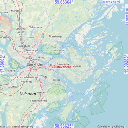
Gustavsberg GPS coordinates[2]
59° 19' 36.624" North, 18° 23' 23.1" East
| Map corner | latitude | longitude |
|---|---|---|
| Upper-left | 59.68364°, | 17.68663° |
| Center: | 59.32684°, | 18.38975° |
| Lower-right: | 58.96625°, | 19.09288° |
| Map W x H: | 79.8×79.8 km | = 49.6×49.6mi |
| max Lat: | 67.85572° ⇑38.8% North |
| Gustavsberg: | 59.32684° |
| min Lat: | ⇓61.2% South 55.34337° |
| min Long | Gustavsberg | max Long |
| 11.1712° | 18.38975° | 24.13676° |
| W 89.9%⇐ | ⇒10.1% E |
Elevation
Elevation of Gustavsberg is 7 m = 23 ft, and this is 75.6 m = 248 ft below average elevation for this country.
| Max E: |
663 m = 2175 ft | 92.6% |
| Avg. | 82.6 m = 271 ft | |
| Gustavsberg | 7 m = 23 ft | |
Min E: |
-1 m = -3 ft | 7.4% |
See also: Sweden elevation on elevation.city.
Geographical zone
Gustavsberg is located in North temperate zone (between Tropic of Cancer and the Arctic Circle). Distance of this North polar circle is 804.6 km =500 mi to North.| Distance of | km | miles | from Gustavsberg |
|---|---|---|---|
| North Pole | 3410.5 | 2119.2 | to North |
| Arctic Circle | 804.6 | 500 | to North |
| Tropic Cancer | 3990.6 | 2479.6 | to South |
| Equator | 6596.5 | 4098.9 | to South |


Nearby cities:
15 places around Gustavsberg: (largest is in red/bold)
• Boo
6.1 km =3.8 mi,  276°
276°
• Brevik
11.1 km =6.9 mi, 283°
• Brunn
5.7 km =3.5 mi,  156°
156°
• Fisksätra
8.6 km =5.3 mi,  242°
242°
• Hemmesta
5.5 km =3.4 mi,  94°
94°
• Kopparmora
11 km =6.8 mi, 86°
• Kummelnäs
6.6 km =4.1 mi,  293°
293°
• Långvik
11.5 km =7.1 mi,  141°
141°
• Mörtnäs
3.2 km =2 mi,  106°
106°
• Oskar-Fredriksborg
8.5 km =5.3 mi,  16°
16°
• Resarö
11.8 km =7.3 mi,  344°
344°
• Rindö
7.8 km =4.8 mi,  1°
1°
• Saltsjöbaden
7 km =4.3 mi,  226°
226°
• Strömma
9.5 km =5.9 mi,  120°
120°
• Vaxholm
8.6 km =5.3 mi,  346°
346°
Sources, notices
• [Note1] Compared only with cities in Sweden existing in our database
• [Src1] Map data: © OpenStreetMap contributors (CC-BY-SA)
• [Src2] Other city data from geonames.org with taken over terms of usage.
• [Src3] Geographical zone / Annual Mean Temperature by Robert A. Rohde @ Wikipedia
