Vaxholm geodata
Vaxholm (Stockholm) is a seat of a second-order administrative division; located in Sweden in Europe/Stockholm (GMT+2) time zone. With population of 4,849 people, there are 282 cities with bigger population in this country. Compared to other cities in Sweden, 64.1% of cities are located further ↓South; 89.4% of cities are located further ←West and 88.4% of cities have higher elevation than Vaxholm. Note1


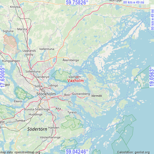
Vaxholm GPS coordinates[2]
59° 24' 8.1" North, 18° 21' 11.412" East
| Map corner | latitude | longitude |
|---|---|---|
| Upper-left | 59.75826°, | 17.65005° |
| Center: | 59.40225°, | 18.35317° |
| Lower-right: | 59.04246°, | 19.0563° |
| Map W x H: | 79.6×79.6 km | = 49.5×49.5mi |
| max Lat: | 67.85572° ⇑35.9% North |
| Vaxholm: | 59.40225° |
| min Lat: | ⇓64.1% South 55.34337° |
| min Long | Vaxholm | max Long |
| 11.1712° | 18.35317° | 24.13676° |
| W 89.4%⇐ | ⇒10.6% E |
Elevation
Elevation of Vaxholm is 10 m = 33 ft, and this is 72.6 m = 238 ft below average elevation for this country.
| Max E: |
663 m = 2175 ft | 88.4% |
| Avg. | 82.6 m = 271 ft | |
| Vaxholm | 10 m = 33 ft | |
Min E: |
-1 m = -3 ft | 11.6% |
See also: Sweden elevation on elevation.city.
Geographical zone
Vaxholm is located in North temperate zone (between Tropic of Cancer and the Arctic Circle). Distance of this North polar circle is 796.3 km =494.8 mi to North.| Distance of | km | miles | from Vaxholm |
|---|---|---|---|
| North Pole | 3402.2 | 2114 | to North |
| Arctic Circle | 796.3 | 494.8 | to North |
| Tropic Cancer | 3999 | 2484.9 | to South |
| Equator | 6604.9 | 4104.1 | to South |


Nearby cities:
15 places around Vaxholm: (largest is in red/bold)
• Boo
8.6 km =5.3 mi,  207°
207°
• Brevik
10.4 km =6.5 mi,  236°
236°
• Brunn
14.3 km =8.9 mi,  162°
162°
• Fisksätra
13.5 km =8.4 mi,  204°
204°
• Gustavsberg
8.6 km =5.3 mi,  166°
166°
• Hemmesta
11.6 km =7.2 mi,  139°
139°
• Kummelnäs
7 km =4.3 mi, 214°
• Lidingö
13.1 km =8.1 mi,  252°
252°
• Mörtnäs
10.6 km =6.6 mi,  151°
151°
• Oskar-Fredriksborg
4.5 km =2.8 mi,  93°
93°
• Resarö
3.2 km =2 mi,  339°
339°
• Rindö
2.4 km =1.5 mi,  104°
104°
• Rydbo
11.6 km =7.2 mi,  304°
304°
• Saltsjöbaden
13.6 km =8.5 mi,  192°
192°
• Åkersberga
9.1 km =5.7 mi, 340°
Sources, notices
• [Note1] Compared only with cities in Sweden existing in our database
• [Src1] Map data: © OpenStreetMap contributors (CC-BY-SA)
• [Src2] Other city data from geonames.org with taken over terms of usage.
• [Src3] Geographical zone / Annual Mean Temperature by Robert A. Rohde @ Wikipedia
