Rättvik geodata
Rättvik (Dalarna) is a seat of a second-order administrative division; located in Sweden in Europe/Stockholm (GMT+2) time zone. With population of 5,160 people, there are 263 cities with bigger population in this country. Compared to other cities in Sweden, 81.9% of cities are located further ↓South; 51.1% of cities are located further ←West and 86.2% of cities have lower elevation than Rättvik. Note1


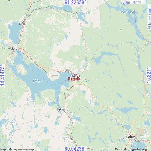
Rättvik GPS coordinates[2]
60° 53' 10.752" North, 15° 7' 4.332" East
| Map corner | latitude | longitude |
|---|---|---|
| Upper-left | 61.22659°, | 14.41475° |
| Center: | 60.88632°, | 15.11787° |
| Lower-right: | 60.54238°, | 15.821° |
| Map W x H: | 76.1×76.1 km | = 47.3×47.3mi |
| max Lat: | 67.85572° ⇑18.1% North |
| Rättvik: | 60.88632° |
| min Lat: | ⇓81.9% South 55.34337° |
| min Long | Rättvik | max Long |
| 11.1712° | 15.11787° | 24.13676° |
| W 51.1%⇐ | ⇒48.9% E |
Elevation
Elevation of Rättvik is 174 m = 571 ft, and this is 91.4 m = 300 ft above average elevation for this country.
| Max E: |
663 m = 2175 ft | 13.8% |
| Rättvik | 174 m 571 ft | |
| Avg. | 82.6 m = 271 ft | |
Min E: |
-1 m = -3 ft | 86.2% |
See also: Sweden elevation on elevation.city.
Geographical zone
Rättvik is located in North temperate zone (between Tropic of Cancer and the Arctic Circle). Distance of this North polar circle is 631.2 km =392.2 mi to North.| Distance of | km | miles | from Rättvik |
|---|---|---|---|
| North Pole | 3237.1 | 2011.4 | to North |
| Arctic Circle | 631.2 | 392.2 | to North |
| Tropic Cancer | 4164 | 2587.4 | to South |
| Equator | 6769.9 | 4206.6 | to South |


Nearby cities:
15 places around Rättvik: (largest is in red/bold)
• Backa
4.2 km =2.6 mi,  346°
346°
• Bjursås
24.6 km =15.3 mi,  132°
132°
• Boda
15.4 km =9.6 mi,  20°
20°
• Färnäs
29.1 km =18.1 mi,  295°
295°
• Grycksbo
29.8 km =18.5 mi,  137°
137°
• Häradsbygden
21.2 km =13.2 mi,  192°
192°
• Insjön
23.3 km =14.5 mi,  183°
183°
• Leksand
18.5 km =11.5 mi,  200°
200°
• Nusnäs
27.7 km =17.2 mi,  288°
288°
• Siljansnäs
18.5 km =11.5 mi,  231°
231°
• Smedby
21 km =13 mi, 190°
• Sollerön
27.3 km =17 mi,  277°
277°
• Sågmyra
20.9 km =13 mi,  154°
154°
• Tällberg
10 km =6.2 mi,  219°
219°
• Vikarbyn
6.4 km =4 mi, 301°
Sources, notices
• [Note1] Compared only with cities in Sweden existing in our database
• [Src1] Map data: © OpenStreetMap contributors (CC-BY-SA)
• [Src2] Other city data from geonames.org with taken over terms of usage.
• [Src3] Geographical zone / Annual Mean Temperature by Robert A. Rohde @ Wikipedia
