Leksand geodata
Leksand (Dalarna) is a seat of a second-order administrative division; located in Sweden in Europe/Stockholm (GMT+2) time zone. With population of 6,107 people, there are 229 cities with bigger population in this country. Compared to other cities in Sweden, 81.1% of cities are located further ↓South; 50.6% of cities are located further →East and 83.8% of cities have lower elevation than Leksand. Note1
Administrative division(s):
- Level 1: Dalarna
- Level 2: Leksands kommun
- Level 3: Djura
- Level 4: Leksand socken


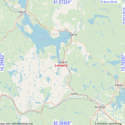
Leksand GPS coordinates[2]
60° 43' 49.08" North, 14° 59' 59.784" East
| Map corner | latitude | longitude |
|---|---|---|
| Upper-left | 61.07224°, | 14.29682° |
| Center: | 60.7303°, | 14.99994° |
| Lower-right: | 60.38468°, | 15.70307° |
| Map W x H: | 76.4×76.4 km | = 47.5×47.5mi |
| max Lat: | 67.85572° ⇑18.9% North |
| Leksand: | 60.7303° |
| min Lat: | ⇓81.1% South 55.34337° |
| min Long | Leksand | max Long |
| 11.1712° | 14.99994° | 24.13676° |
| W 49.4%⇐ | ⇒50.6% E |
Elevation
Elevation of Leksand is 163 m = 535 ft, and this is 80.4 m = 264 ft above average elevation for this country.
| Max E: |
663 m = 2175 ft | 16.2% |
| Leksand | 163 m 535 ft | |
| Avg. | 82.6 m = 271 ft | |
Min E: |
-1 m = -3 ft | 83.8% |
See also: Sweden elevation on elevation.city.
Geographical zone
Leksand is located in North temperate zone (between Tropic of Cancer and the Arctic Circle). Distance of this North polar circle is 648.6 km =403 mi to North.| Distance of | km | miles | from Leksand |
|---|---|---|---|
| North Pole | 3254.5 | 2022.3 | to North |
| Arctic Circle | 648.6 | 403 | to North |
| Tropic Cancer | 4146.7 | 2576.6 | to South |
| Equator | 6752.6 | 4195.9 | to South |


Nearby cities:
15 places around Leksand: (largest is in red/bold)
• Backa
22.1 km =13.7 mi,  14°
14°
• Bjursås
24.6 km =15.3 mi,  88°
88°
• Bäsna
24.5 km =15.2 mi,  153°
153°
• Djurmo
22.4 km =13.9 mi, 153°
• Djurås
20.2 km =12.6 mi,  159°
159°
• Gagnef
15.2 km =9.4 mi, 163°
• Häradsbygden
3.8 km =2.4 mi, 151°
• Insjön
7.9 km =4.9 mi,  138°
138°
• Mockfjärd
25.7 km =16 mi,  184°
184°
• Rättvik
18.5 km =11.5 mi,  20°
20°
• Siljansnäs
10.1 km =6.3 mi,  305°
305°
• Smedby
4.3 km =2.7 mi, 141°
• Sågmyra
15.5 km =9.6 mi,  95°
95°
• Tällberg
9.6 km =6 mi,  0°
0°
• Vikarbyn
20.7 km =12.9 mi, 2°
Sources, notices
• [Note1] Compared only with cities in Sweden existing in our database
• [Src1] Map data: © OpenStreetMap contributors (CC-BY-SA)
• [Src2] Other city data from geonames.org with taken over terms of usage.
• [Src3] Geographical zone / Annual Mean Temperature by Robert A. Rohde @ Wikipedia
