Sundbyberg geodata
Sundbyberg (Stockholm) is a seat of a second-order administrative division; located in Sweden in Europe/Stockholm (GMT+2) time zone. With population of 34,529 people, there are 45 cities with bigger population in this country. Compared to other cities in Sweden, 62.4% of cities are located further ↓South; 85.5% of cities are located further ←West and 70.9% of cities have higher elevation than Sundbyberg. Note1


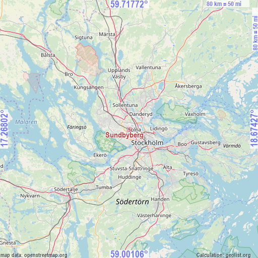
Sundbyberg GPS coordinates[2]
59° 21' 40.608" North, 17° 58' 16.104" East
| Map corner | latitude | longitude |
|---|---|---|
| Upper-left | 59.71772°, | 17.26802° |
| Center: | 59.36128°, | 17.97114° |
| Lower-right: | 59.00106°, | 18.67427° |
| Map W x H: | 79.7×79.7 km | = 49.5×49.5mi |
| max Lat: | 67.85572° ⇑37.6% North |
| Sundbyberg: | 59.36128° |
| min Lat: | ⇓62.4% South 55.34337° |
| min Long | Sundbyberg | max Long |
| 11.1712° | 17.97114° | 24.13676° |
| W 85.5%⇐ | ⇒14.5% E |
Elevation
Elevation of Sundbyberg is 24 m = 79 ft, and this is 58.6 m = 192 ft below average elevation for this country.
| Max E: |
663 m = 2175 ft | 70.9% |
| Avg. | 82.6 m = 271 ft | |
| Sundbyberg | 24 m = 79 ft | |
Min E: |
-1 m = -3 ft | 29.1% |
See also: Sweden elevation on elevation.city.
Geographical zone
Sundbyberg is located in North temperate zone (between Tropic of Cancer and the Arctic Circle). Distance of this North polar circle is 800.8 km =497.6 mi to North.| Distance of | km | miles | from Sundbyberg |
|---|---|---|---|
| North Pole | 3406.7 | 2116.8 | to North |
| Arctic Circle | 800.8 | 497.6 | to North |
| Tropic Cancer | 3994.4 | 2482 | to South |
| Equator | 6600.4 | 4101.3 | to South |


Nearby cities:
15 places around Sundbyberg: (largest is in red/bold)
• Akalla
6.8 km =4.2 mi,  331°
331°
• Alvik
3.3 km =2.1 mi,  168°
168°
• Bergshamra
4.2 km =2.6 mi,  58°
58°
• Bromma
3 km =1.9 mi,  216°
216°
• Djursholm
6.4 km =4 mi,  48°
48°
• Gamla Stan
6.9 km =4.3 mi,  124°
124°
• Kista
4.9 km =3 mi,  342°
342°
• Kungsholmen
5.1 km =3.2 mi,  129°
129°
• Råsunda
1.5 km =0.9 mi,  69°
69°
• Sollentuna
7.5 km =4.7 mi,  351°
351°
• Solna
1.7 km =1.1 mi,  94°
94°
• Stockholm
6.2 km =3.9 mi, 120°
• Tensta
5.4 km =3.4 mi,  312°
312°
• Vasastan
4.8 km =3 mi,  111°
111°
• Östermalm
6.9 km =4.3 mi, 111°
Sources, notices
• [Note1] Compared only with cities in Sweden existing in our database
• [Src1] Map data: © OpenStreetMap contributors (CC-BY-SA)
• [Src2] Other city data from geonames.org with taken over terms of usage.
• [Src3] Geographical zone / Annual Mean Temperature by Robert A. Rohde @ Wikipedia
