Hököpinge geodata
Hököpinge (Skåne) is a populated place; located in Sweden in Europe/Stockholm (GMT+2) time zone. With population of 1,164 people, there are 756 cities with bigger population in this country. Compared to other cities in Sweden, 98.2% of cities are located further ↑North; 79.8% of cities are located further →East and 80.1% of cities have higher elevation than Hököpinge. Note1


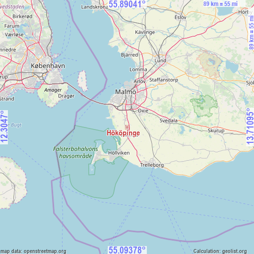
Hököpinge GPS coordinates[2]
55° 29' 38.796" North, 13° 0' 28.152" East
| Map corner | latitude | longitude |
|---|---|---|
| Upper-left | 55.89041°, | 12.3047° |
| Center: | 55.49411°, | 13.00782° |
| Lower-right: | 55.09378°, | 13.71095° |
| Map W x H: | 88.6×88.6 km | = 55.1×55.1mi |
| max Lat: | 67.85572° ⇑98.2% North |
| Hököpinge: | 55.49411° |
| min Lat: | ⇓1.8% South 55.34337° |
| min Long | Hököpinge | max Long |
| 11.1712° | 13.00782° | 24.13676° |
| W 20.2%⇐ | ⇒79.8% E |
Elevation
Elevation of Hököpinge is 16 m = 52 ft, and this is 66.6 m = 219 ft below average elevation for this country.
| Max E: |
663 m = 2175 ft | 80.1% |
| Avg. | 82.6 m = 271 ft | |
| Hököpinge | 16 m = 52 ft | |
Min E: |
-1 m = -3 ft | 19.9% |
See also: Sweden elevation on elevation.city.
Geographical zone
Hököpinge is located in North temperate zone (between Tropic of Cancer and the Arctic Circle). Distance of this North polar circle is 1230.8 km =764.8 mi to North.| Distance of | km | miles | from Hököpinge |
|---|---|---|---|
| North Pole | 3836.7 | 2384 | to North |
| Arctic Circle | 1230.8 | 764.8 | to North |
| Tropic Cancer | 3564.4 | 2214.8 | to South |
| Equator | 6170.4 | 3834.1 | to South |


Nearby cities:
15 places around Hököpinge: (largest is in red/bold)
• Bunkeflostrand
7.7 km =4.8 mi,  316°
316°
• Gessie Villastad
3.2 km =2 mi,  281°
281°
• Höllviken
9.9 km =6.2 mi,  199°
199°
• Kurland
14.1 km =8.8 mi,  160°
160°
• Ljunghusen
11.9 km =7.4 mi,  206°
206°
• Malmö
12.4 km =7.7 mi,  357°
357°
• Oxie
7.6 km =4.7 mi,  47°
47°
• Skegrie
10.7 km =6.6 mi, 155°
• Skåre
12.6 km =7.8 mi,  167°
167°
• Svedala
14.4 km =8.9 mi,  83°
83°
• Tygelsjö
2.6 km =1.6 mi,  348°
348°
• Vellinge
2.7 km =1.7 mi, 163°
• Vintrie
6.7 km =4.2 mi,  337°
337°
• Västra Ingelstad
6.6 km =4.1 mi,  92°
92°
• Östra Grevie
8.5 km =5.3 mi,  111°
111°
Sources, notices
• [Note1] Compared only with cities in Sweden existing in our database
• [Src1] Map data: © OpenStreetMap contributors (CC-BY-SA)
• [Src2] Other city data from geonames.org with taken over terms of usage.
• [Src3] Geographical zone / Annual Mean Temperature by Robert A. Rohde @ Wikipedia
