Bunkeflostrand geodata
Bunkeflostrand (Skåne) is a populated place; located in Sweden in Europe/Stockholm (GMT+2) time zone. With population of 13,048 people, there are 119 cities with bigger population in this country. Compared to other cities in Sweden, 97.7% of cities are located further ↑North; 82.3% of cities are located further →East and 96.4% of cities have higher elevation than Bunkeflostrand. Note1


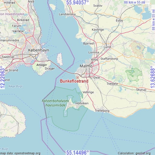
Bunkeflostrand GPS coordinates[2]
55° 32' 41.208" North, 12° 55' 25.5" East
| Map corner | latitude | longitude |
|---|---|---|
| Upper-left | 55.94057°, | 12.22063° |
| Center: | 55.54478°, | 12.92375° |
| Lower-right: | 55.14496°, | 13.62688° |
| Map W x H: | 88.5×88.5 km | = 55×55mi |
| max Lat: | 67.85572° ⇑97.7% North |
| Bunkeflostrand: | 55.54478° |
| min Lat: | ⇓2.3% South 55.34337° |
| min Long | Bunkeflostrand | max Long |
| 11.1712° | 12.92375° | 24.13676° |
| W 17.7%⇐ | ⇒82.3% E |
Elevation
Elevation of Bunkeflostrand is 4 m = 13 ft, and this is 78.6 m = 258 ft below average elevation for this country.
| Max E: |
663 m = 2175 ft | 96.4% |
| Avg. | 82.6 m = 271 ft | |
| Bunkeflostrand | 4 m = 13 ft | |
Min E: |
-1 m = -3 ft | 3.6% |
See also: Sweden elevation on elevation.city.
Geographical zone
Bunkeflostrand is located in North temperate zone (between Tropic of Cancer and the Arctic Circle). Distance of this North polar circle is 1225.2 km =761.3 mi to North.| Distance of | km | miles | from Bunkeflostrand |
|---|---|---|---|
| North Pole | 3831.1 | 2380.5 | to North |
| Arctic Circle | 1225.2 | 761.3 | to North |
| Tropic Cancer | 3570.1 | 2218.4 | to South |
| Equator | 6176 | 3837.6 | to South |


Nearby cities:
15 places around Bunkeflostrand: (largest is in red/bold)
• Arlöv
13.5 km =8.4 mi,  43°
43°
• Bara
16.5 km =10.3 mi,  75°
75°
• Gessie Villastad
5.4 km =3.4 mi,  156°
156°
• Hököpinge
7.7 km =4.8 mi,  136°
136°
• Höllviken
15.1 km =9.4 mi,  172°
172°
• Ljunghusen
16.3 km =10.1 mi,  179°
179°
• Lomma
16.9 km =10.5 mi,  32°
32°
• Malmö
8.3 km =5.2 mi, 35°
• Oxie
10.9 km =6.8 mi,  92°
92°
• Skanör med Falsterbo
16.8 km =10.4 mi,  196°
196°
• Tygelsjö
5.7 km =3.5 mi,  123°
123°
• Vellinge
10.2 km =6.3 mi, 143°
• Vintrie
2.8 km =1.7 mi, 77°
• Västra Ingelstad
13.3 km =8.3 mi, 116°
• Östra Grevie
15.8 km =9.8 mi, 123°
Sources, notices
• [Note1] Compared only with cities in Sweden existing in our database
• [Src1] Map data: © OpenStreetMap contributors (CC-BY-SA)
• [Src2] Other city data from geonames.org with taken over terms of usage.
• [Src3] Geographical zone / Annual Mean Temperature by Robert A. Rohde @ Wikipedia
