Höganäs geodata
Höganäs (Skåne) is a seat of a second-order administrative division; located in Sweden in Europe/Stockholm (GMT+2) time zone. With population of 14,778 people, there are 108 cities with bigger population in this country. Compared to other cities in Sweden, 88.1% of cities are located further ↑North; 87.7% of cities are located further →East and 93.9% of cities have higher elevation than Höganäs. Note1


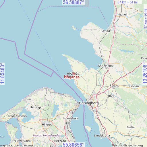
Höganäs GPS coordinates[2]
56° 11' 58.956" North, 12° 33' 28.62" East
| Map corner | latitude | longitude |
|---|---|---|
| Upper-left | 56.58887°, | 11.85483° |
| Center: | 56.19971°, | 12.55795° |
| Lower-right: | 55.80656°, | 13.26108° |
| Map W x H: | 87×87 km | = 54.1×54.1mi |
| max Lat: | 67.85572° ⇑88.1% North |
| Höganäs: | 56.19971° |
| min Lat: | ⇓11.9% South 55.34337° |
| min Long | Höganäs | max Long |
| 11.1712° | 12.55795° | 24.13676° |
| W 12.3%⇐ | ⇒87.7% E |
Elevation
Elevation of Höganäs is 6 m = 20 ft, and this is 76.6 m = 251 ft below average elevation for this country.
| Max E: |
663 m = 2175 ft | 93.9% |
| Avg. | 82.6 m = 271 ft | |
| Höganäs | 6 m = 20 ft | |
Min E: |
-1 m = -3 ft | 6.1% |
See also: Sweden elevation on elevation.city.
Geographical zone
Höganäs is located in North temperate zone (between Tropic of Cancer and the Arctic Circle). Distance of this North polar circle is 1152.4 km =716.1 mi to North.| Distance of | km | miles | from Höganäs |
|---|---|---|---|
| North Pole | 3758.2 | 2335.2 | to North |
| Arctic Circle | 1152.4 | 716.1 | to North |
| Tropic Cancer | 3642.9 | 2263.6 | to South |
| Equator | 6248.8 | 3882.8 | to South |


Nearby cities:
15 places around Höganäs: (largest is in red/bold)
• Allerum
12.2 km =7.6 mi,  136°
136°
• Arild
8.4 km =5.2 mi,  7°
7°
• Domsten
9.5 km =5.9 mi,  161°
161°
• Hasslarp
17.6 km =10.9 mi,  114°
114°
• Helsingborg
19 km =11.8 mi,  153°
153°
• Hittarp
12 km =7.5 mi, 157°
• Jonstorp
8 km =5 mi,  61°
61°
• Kattarp
15.4 km =9.6 mi,  115°
115°
• Mölle
10 km =6.2 mi,  338°
338°
• Skepparkroken
18.1 km =11.2 mi, 55°
• Strövelstorp
17.7 km =11 mi,  100°
100°
• Vejbystrand
18.4 km =11.4 mi,  44°
44°
• Viken
5.6 km =3.5 mi,  169°
169°
• Ängelholm
19.4 km =12.1 mi,  75°
75°
• Ödåkra
15.8 km =9.8 mi,  132°
132°
Sources, notices
• [Note1] Compared only with cities in Sweden existing in our database
• [Src1] Map data: © OpenStreetMap contributors (CC-BY-SA)
• [Src2] Other city data from geonames.org with taken over terms of usage.
• [Src3] Geographical zone / Annual Mean Temperature by Robert A. Rohde @ Wikipedia
